
 |
Upper Mississippi River Restoration ProgramLong Term Resource Monitoring |
|
| |
||
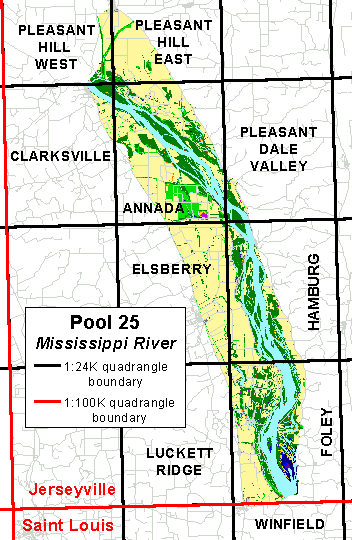
Mississippi River - Pool 25River Mile 241.5-273Updated May 7, 2018 |
|
Upper Mississippi River System (UMRS) Pool 25 is used to describe the region of the UMRS that is impounded by Lock and Dam 25. It extends from Lock and Dam 25 located near Winfield, Missouri upstream to Lock and Dam 24 located near Clarksville, Missouri.
National Atlas and Seamless data server data have been moved to the National Map.
Orthoreferenced Color Infrared Images
In 2010, the EMP partnered with the USFWS to fly and acquire CIR digital aerial photography of Pools 1-13, Upper Mississippi River and Pools Alton–Marseilles, Illinois River at 8"/pixel and 16"/pixel respectively using a mapping-grade Applanix DSS439 digital aerial camera . The photography was collected at a minimum accuracy of 5-10 meters. These are the orthorectified photo mosaics for all or portions of the coverage area. The flights occurred during times of peak vegetation biomass, from August 13, 2010 through September 1, 2010. The mosaics are served as orthoreferenced JPEG2000 images.
![]()
![]() - 2011 Pool 25 Orthoreferenced Color Infrared Image (266 MB JPG2000)
- 2011 Pool 25 Orthoreferenced Color Infrared Image (266 MB JPG2000)
On occasion the Center will scan and register aerial photography for special projects. As these data sets are created they're also made available through Web site. For information on how to download these data and obtain a free viewer program or the required .dll files for your GIS program, activate the help button.
The Aquatic Areas data sets were created to identify areas of similar aquatic habitats. These data are available as polygons and linears. The linear data set contains data for features too narrow to be mapped as polygons (e.g., wing dams, rip rap). For additional information, access the help button.
![]() Lidar (Light Detection And Ranging) data are remotely sensed, high-resolution elevation data collected by airplane. The Upper Midwest Environmental Sciences Center processed these data to create Digital Elevation Models (DEMs), 0.5 meter contour lines, and pool-wide hillshade images. A second tier of data processing has been completed for this pool. These processes include water-masking, contour-smoothing, point reclassification, where needed, and additional quality control steps. These data are a product of the U.S. Army Corps of Engineers’ Upper Mississippi River Restoration (UMRR) Program Long Term Resource Monitoring (LTRM) element, as distributed by the U.S. Geological Survey, Upper Midwest Environmental Sciences Center, La Crosse, Wisconsin.
Lidar (Light Detection And Ranging) data are remotely sensed, high-resolution elevation data collected by airplane. The Upper Midwest Environmental Sciences Center processed these data to create Digital Elevation Models (DEMs), 0.5 meter contour lines, and pool-wide hillshade images. A second tier of data processing has been completed for this pool. These processes include water-masking, contour-smoothing, point reclassification, where needed, and additional quality control steps. These data are a product of the U.S. Army Corps of Engineers’ Upper Mississippi River Restoration (UMRR) Program Long Term Resource Monitoring (LTRM) element, as distributed by the U.S. Geological Survey, Upper Midwest Environmental Sciences Center, La Crosse, Wisconsin.
Quadrangle Name |
DEMs |
Contour |
| Annada - 24K quad | qn4c7_dem.exe (320 MB) | qn4c7_con.exe (194 MB) |
| Clarksville - 24K quad | qn4c8_dem.exe (33 MB) | qn4c8_con.exe (27 MB) |
| Elsberry - 24K quad | qn4b7_dem.exe (136 MB) | qn4b7_con.exe (56 MB) |
| Foley - 24K quad | qn4a6_dem.exe (176 MB) | qn4a6_con.exe (172 MB) |
| Hamburg - 24K quad | qn4b6_dem.exe (209 MB) | qn4b6_con.exe (154 MB) |
| Luckett Ridge - 24K quad | qn4a7_dem.exe (5 MB) | qn4a7_con.exe (3 MB) |
| Pleasant Dale Valley - 24K quad | qn4c6_dem.exe (43 MB) | qn4c6_con.exe (60 MB) |
| Pleasant Hill East - 24K quad | qn4d7_dem.exe (99 MB) | qn4d7_con.exe (67 MB) |
| Pleasant Hill West - 24K quad | qn4d8_dem.exe (70 MB) | qn4d8_con.exe (35 MB) |
| Winfield - 24K quad | st2h6_dem.exe (15 MB) | st2h6_con.exe (8 MB) |
Hillshade image |
First return |
Last return |
| Navigation Pool 25 | 2011_p25_hsf.exe (258 MB) | 2011_p25_hsl.exe (187 MB) |
Topobathy
Separate Lidar and bathymetry data were collected on the Upper Mississippi River System (UMRS) by the US Army Corps of Engineers (USACE), Upper Mississippi River Restoration (UMRR) program. While many information needs can be met by using these data separately, in many cases seamless elevation data across the river and its floodplain are needed. This seamless elevation surface was generated by merging the Lidar and bathymetry data.
![]() Digital Orthophoto Quadrangles (DOQ)
Digital Orthophoto Quadrangles (DOQ)
Digital orthophoto quadrangles (DOQ) are georeferenced images of aerial photographs that have had camera orientation and terrain displacements removed.
These data are being compressed and redistributed through this web site as a service for program partners of the Upper Midwest Environmental Sciences Center. If you require data for areas outside the Mississippi River floodplain, data sets made from photographs from a different year, or the uncompressed files, contact the EROS Data Center.
|
Quadrangle Name
|
Northwest
|
Southwest
|
Northeast
|
Southeast
|
| Annada - 24K quad | N/A | N/A | N/A | N/A |
| Clarksville - 24K quad | N/A | N/A | N/A | N/A |
| Elsberry - 24K quad | N/A | N/A | N/A | N/A |
| Foley - 24K quad | N/A | N/A | N/A | N/A |
| Hamburg - 24K quad | N/A | N/A | N/A | N/A |
| Luckett Ridge - 24K quad | N/A | N/A | N/A | N/A |
| Pleasant Dale Valley - 24K quad | N/A | N/A | N/A | N/A |
| Pleasant Hill East - 24K quad | N/A | N/A | N/A | N/A |
| Pleasant Hill West - 24K quad | N/A | N/A | N/A | N/A |
| Winfield - 24K quad | N/A | N/A | N/A | N/A |
|
Composite Image
|
DOQ
|
|||
| Navigation Pool 25 | ||||
Digital raster graphic (DRG) files are scanned and rectified images of USGS quadrangles.
These data are being compressed and redistributed through this web site as a service for program partners of the Upper Midwest Environmental Sciences Center. If you require data for additional areas, the help button access information on which files are available through this Web site, the USGS National Mapping Center in Rolla, Missouri keeps a listing of sites that distribute DRG files through the Internet, and copies of the data can be ordered from the EROS Data Center (for a duplication and distribution fee).
|
Quadrangle Name
|
Original Image
|
Overlapping Image
|
| Jerseyville - 100K quad | qn4_drg1.exe (7.6 MB) | N/A |
| Saint Louis - 100K quad | st2_drg1.exe (9.9 MB) | N/A |
| Annada - 24K quad | N/A | qn4c7_drg2.exe (3.2 MB) |
| Clarksville - 24K quad | N/A | qn4c8_drg2.exe (3.9 MB) |
| Elsberry - 24K quad | N/A | qn4b7_drg2.exe (2.6 MB) |
| Foley - 24K quad | N/A | qn4a6_drg2.exe (4.3 MB) |
| Hamburg - 24K quad | N/A | qn4b6_drg2.exe (4.5 MB) |
| Luckett Ridge - 24K quad | N/A | qn4a7_drg2.exe (3.0 MB) |
| Pleasant Dale Valley - 24K quad | N/A | qn4c6_drg2.exe (4.0 MB) |
| Pleasant Hill East - 24K quad | N/A | qn4d7_drg2.exe (3.0 MB) |
| Pleasant Hill West - 24K quad | N/A | qn4d8_drg2.exe (3.7 MB) |
| Winfield - 24K quad | N/A | st2h6_drg2.exe (3.9 MB) |
|
Composite Image
|
100K Color
|
100K Gray Scale
|
| Navigation Pool 25 | drg_p25_clr100k_z15n83.exe (4.9 MB) | drg_p25_bw100k_z15n83.exe (4.8 MB) |
Since 1989 the Upper Midwest Environmental Sciences Center through its association with the Upper Mississippi River Restoration Programs Long Term Resource Monitoring element, has been creating land cover/use and other riverine datasets for the Upper Mississippi River System. For background information on how these data sets were created and are attributed, see the associated metadata in each geodatabase.
Since 1989 the Upper Midwest Environmental Center through its association with the Long Term Resource Monitoring Program has been creating land cover/use data sets for the Upper Mississippi River System. For background information on how these data sets were created and are attributed, activate the help buttons. A link to a freeware GIS data viewer that can read the Shape files is also available.
Land/water is one of the classification attributes in the land cover/use data sets created by UMESC from aerial photography. These data are redistributed here as shape files with the boundaries of the region's 1:24,000-scale USGS quadrangles added to the data. This has been done because individuals working with ArcView have reported numerous problems if they attempt to perform a dissolve on the land cover/use data to create a land/water only shape file. Most printers cannot process the detailed land/water boundaries unless some form of a break line or lines are added.
![]()
![]()
![]() - 1890's Map Plates - Georeferenced Images of Maps Produced by the Mississippi River Commission (22.6 MB z15n27 MrSid) (22.6 MB z15n83 MrSid)
- 1890's Map Plates - Georeferenced Images of Maps Produced by the Mississippi River Commission (22.6 MB z15n27 MrSid) (22.6 MB z15n83 MrSid)
The U.S. Army Corps of Engineers use a river mile measuring scheme to locate features on the Mississippi River. Two digital version of these data are available, one created by UMESC from stored on USGS quadrangles, and one created by the SAST project. The SAST data set differs from the UMESC data set in that some of the river mile markers were relocated by UMESC staff so they would fall within the navigation channel.
![]() UMRS Basin
UMRS Basin
![]() Lock and dam 10 to the Ohio River
Lock and dam 10 to the Ohio River
The Corps of Engineers constructs and maintains wing dams in the Mississippi River system. Copies of data files provided by the US Army Corps of Engineers - Rock Island District are being redistributed through this web site as a service for program partners of the Upper Midwest Environmental Sciences Center.

Page Last Modified: May 7, 2018