
 |
Upper Mississippi River Restoration ProgramLong Term Resource Monitoring |
|
| |
||
Land Cover/Use
Data |
||
2020 Land Cover/Land Use
|
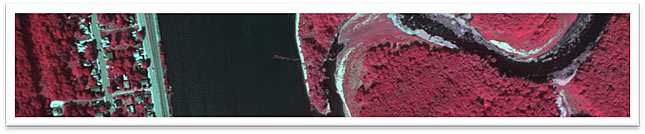
The fourth generation of systemic-wide UMRS aerial imagery and LCU maps begin in 2020. The 2020 aerial imagery is also the second generation of a fully digital acquisition of systemic-wide coverage of the UMRS, the first being the 2010/11 acquisition. The aerial imagery is produced into orthoimage mosaics for each UMRS pool or reach and is accessible with GIS. The imagery is also processed for 3D viewing using specialized computer software, monitors, and glasses. These 3D computer mapping systems help image interpreters (mappers) identify ground features using color, form, texture, height, and location on the landscape. Before mappers begin mapping, they visit representative areas to learn how vegetation appear on the 2020 aerial imagery. This promotes accurate interpretation of vegetation to apply polygon delineation and classification. The mapping is developed into LCU datasets for each UMRS pool or reach and is accessible with GIS. Both the orthoimage mosaics and LCU datasets are served online for public access. |
What remains the same as the 2010/11 LCU?
Much does! Here are a few items.
- As with all previous systemic-wide UMRS acquisitions of aerial imagery, including the 2010/11 imagery, the seasonal collection dates remain similar for the 2020 imagery acquisition, starting the second week in August and concluding the first week in September; however, the 1989 collection concluded in early October. The goal is to acquire imagery with vegetation at or near peak biomass.
- The same aerial-image resolutions used for the 2010/11 digital acquisition is used for the 2020 digital acquisition. The 2020 digital aerial imagery is again set to collect 0.2-meter/pixel (8-inch/pixel) for Pool 13 and areas above, and 0.4-meter/pixel (16-inch/pixel) for Pool 14 and areas below (including the Illinois River system). The reason for the increased image resolution for Pool 13 and above is to support greater map detail than applied to Pool 14 and below.
- The minimum mapping unit (MMU) applied in mapping. The MMU remains at 0.5 hectares (1.25 acres) for Pool 13 and above and 1.0 hectares (2.5 acres) for Pools 14 and below (including the Illinois River). The reason for the lower MMU for Pool 13 and above is to support the detail needed to map the higher diversity of vegetation; Pool 14 and below continue to receive standard level of map detail.
- Even though forward progress continued in 3D computer mapping systems since the mapping of 2010/11 LCU, on-screen 3D mapping in GIS remains the tool to produce the 2020 LCU database.
- Orthoimage mosaics and LCU data sets will again be parsed by pools or reaches using the same SAB for UMRS.
What are changes from the 2010/11 LCU?
A couple things, and they are good ones!
- New camera sensors are used to collect the 2020 aerial imagery having higher pixel resolution than the cameras used to collect the 2010/11 imagery. This does not mean the 2020 imagery are collected at higher pixel resolutions than the 2010/11 imagery, but it does change the flight plan altitude and imagery foot prints to accommodate the same pixel resolution. The biggest advantage these new cameras bring to the table is the ability to collect four-bands of imagery, making the imagery viewable as natural color or color infrared.
- During the 2020 UMRS LCU mapping process, the 2010/11 UMRS LCU linework and classification are thoroughly reviewed to help maintain consistency, when applicable, between the two spatial databases.
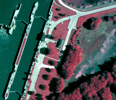 Image sample 0.2-meter (8-inch) pixel resolution |
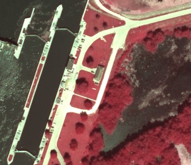 Image sample 0.4-meter (16-inch) pixel resolution. |
Component specialists: Jennifer Dieck and Andrew Strassman

Page Last Modified: October 17, 2024