
 |
Upper Mississippi River Restoration ProgramLong Term Resource Monitoring |
|
| |
||
Land Cover/Use
Data |
||
1890s Maps and Land Cover/Land Use

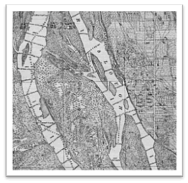
In the late 1880's and early 1900's the Mississippi River Commission (MRC) conducted an extensive high-resolution survey of the Mississippi River from Cairo, Illinois to Minneapolis, Minnesota. These data were published as a series of 89 survey maps and index. Other data on the maps that were not automated include; elevation contours, water depth soundings, proposed water control structures (e.g., wing dams), levees, benchmarks, railroads, and city streets. However, this information is available since these maps were scanned, georeferenced, and mosaicked by pool and are served on the Center’s web site.
In addition to the mosaics, in the 1990's, the Upper Midwest Environmental Sciences Center (UMESC) in conjunction with the Long Term Resource Monitoring Program (LTRMP) for the Upper Mississippi River automated the maps' land cover/land use symbology to create a turn of the century/pre-impoundment land cover/use data set. These data were referenced using the map’s existing lines of latitude and longitude.
Descriptive text printed on the map series reads as follows: The Mississippi River and adjacent topography was reduced from detail maps, projected and drawn from surveys made under the direction of the Mississippi River Commission in the years 1880 to 1882, 1884, 1888, 1889, and 1891 to 1899 - expecting the part below the upper limits of Cairo, Ill., which was reduced from maps projected and drawn from surveys made under the direction of C.B.Comstock, Major, Corps of Engineers, Bvt. Brig. Genl., U.S.A., in the years 1876 and 1877. The remainder of the map was compiled from surveys of the Missouri River Commission; surveys of the Corps of Engineers, U.S.A.; U.S. Land surveys; Railroad surveys; State, County and Township maps and other reliable sources. Compiled and drawn under the direction of J.A.Ockerson, Principal Assistant Engineer, and C.W.Clark, Assistant Engineer, in the office of the Secretary of the Mississippi River Commission, by C.S.Clark, Assistant Engineer, H.A.H.d'Ailly and A.A.Aguirre.

Page Last Modified: January 24, 2020