 |
Upper Mississippi River Restoration ProgramLong Term Resource Monitoring |
|
 |
||
Vegetation - Stratified Random Sampling
Study Areas
|
|
|
|
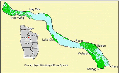
Navigation Pool 4 is 73.3 km (44 river miles) long and includes 14,700 ha (36,300 acres) of aquatic habitat. It is located between Lock and Dam 3 (above Red Wing, Minnesota) and Lock and Dam 4 (Alma, Wisconsin). Major tributaries include the Cannon and Vermillion Rivers on the Minnesota side and the much larger Chippewa River on the Wisconsin side. Lake Pepin, a riverine lake created by the Chippewa River delta, is located in the middle of Pool 4. The location of Lake Pepin divides the rest of the pool into upper Pool 4 and lower Pool 4. The smaller backwaters of upper Pool 4 have been degraded by sedimentation, whereas the larger backwaters of lower Pool 4 are much better habitat for vegetation. |
|
|
|
|
|
|
|
|
|
|
|
|
|
|
|
|
|
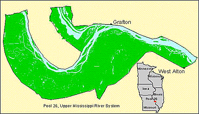
The Navigation Pool 26 study area includes water bodies along the Upper Mississippi River from Lock and Dam 25 (Winfield, Missouri) to Lock and Dam 26 (Alton, Illinois) and the lower Illinois River from its confluence with the Mississippi River north to Illinois River mile 12. This reach of the two rivers is bordered by high bluffs on the Illinois side and low elevation floodplain on the Missouri side. The reach encompasses 9,500 ha (23,700 acres) of aquatic habitat. Presently, most of the backwaters of the lower Illinois River are isolated from the river by low levees so as to decrease sedimentation and allow management for waterfowl. Likewise, many of the secondary channels of the Mississippi River are isolated from the river on the upstream side to create backwaters and to reduce sedimentation. |
|
|
|
|
|
|
Page Last Modified: May 29, 2018


