
 |
Upper Mississippi River Restoration ProgramLong Term Resource Monitoring |
|
| |
||
New Technologies |
||
Aerial photography:
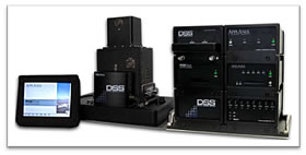
If collected at a large-scale and properly scanned, analog film can have higher resolution capabilities than digital photography, but that resolution comes at a size cost that must be considered in terms of storage and computer processing. The larger an image, the more hard drive space you need to archive it and the more computer power you need to display and manipulate it. There are other reasons why the aerial photography industry is transitioning to digital aerial photo acquisition, including vastly larger payloads and lighter weight, real-time image quality assessment, extensive image information, and the elimination of color infrared 9X9 roll film. In 2009, the 39-megapixel Applanix DSS 439 was selected to replace the Jena LKM 2000 9X9 film camera that was purchased in 1989. The DSS 439 is paired with a 40mm lens and has a sensor size of 7212 X 5408 pixels, which is similar to a 9-inch X 7-inch aerial photo scanned at 800 dots per inch. This camera is being used to collect the aerial photography that the Long Term Resource Monitoring Program’s 2010 systemic land cover/land use (LCU) dataset will be based on.Another advantage of digital aerial photography is the ability of GIS software to automate the process of generating orthorectified aerial photo mosaics. The camera’s Global Positioning System (GPS) and Inertial Measurement Unit (IMU) collect precise three-dimensional information regarding the sensor’s location and position in space. Specialized GIS software can use this this information, shown below, along with a digital elevation model, to ‘drape’ imagery over the landscape in a process called orthorectification. Once orthorectified, all images within a particular block are aligned to each other and can be mosaicked into a single larger image. Since these mosaics can be many gigabytes in size, compression software is used to reduce their size enough to serve over the internet. These mosaics will be available on the GIS Data Download page.
| Image metadata, generated by the digital camera’s GPS and IMU, is used to georeference and mosaic aerial photos. |
 |
 |
 |
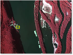
| Digital Aerial Camera | 8”/pixel Color Infrared Photo | Detail at 8”/pixel |
Groundtruthing:
Before aerial photos are interpreted and classified by Center botanists, the photos are taken out into the field where the photo can be compared to the actual vegetation on the ground, a process known as groundtruthing.During this exercise, specific sites are visited and notes are taken about species composition, height, and relative cover percentage along with other relevant information such as soil type, aspect, elevation, or hydrology. In the past, 9X9 contact prints encased in clear plastic sleeves were used and notes were written directly on the sleeve with a permanent marker. Care needed to be taken that the sleeve and photo were precisely aligned and that the photos, which could number in the hundreds, were kept organized.
Once the 9X9 camera was retired and the digital camera employed, another method of groundtruthing was necessary. Since the photos were now georeferenced digital images instead of paper prints, it made sense to view them with a computer rather than to print them out.UMESC began reviewing lightweight computers and tablet PCs and found a ruggedized version of the latter to be the best method of viewing photos and taking notes in the field. These units have tethered pens for note-taking, daylight viewable screen, hot-swappable batteries, GPS-capability, and fast processors enabling them to run GIS applications for a full-day in almost any weather condition. Since the photos are referenced to the earth, any notes or vegetation delineations on the photos are likewise referenced, and the integrated GPS allows for real-time positioning through the photos.
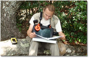 Tablets can be used in full sun or rain. |
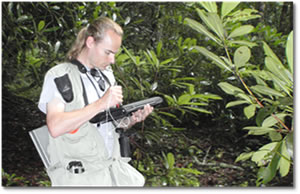 Notes can be added directly to the photos. |
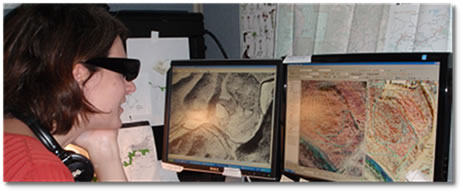
GIS hardware and software:
- 3D Stereo Monitors – there are two methods for viewing images in stereo: 1) active method - monitors that can refresh at 120Hz or faster and synch with shutter glasses at the same rate, or 2) passive method - dual monitors that use a polarizing screen and polarizing glasses to display data to the left and right individually. Both the older, bulky CRT monitors and the more recently available LCD/LED monitors can refresh the screen image fast enough to flash the left and right stereo pairs at 60 Hz (60 times per second), a rate fast enough the eye does not detect flashing. Several manufacturers make LCD stereo monitors, including Acer, Alienware, Asus, LG, Planar, Samsung and ViewSonic. The shutter glasses reduce half the light each eye receives so the surrounding work area can seem darker than normal. The polarizing glasses let all the light through but the dual monitor setup is considerably more expensive than the 120 Hz monitor/shutter glasses option and requires a larger work space to accommodate the dual monitors.
- 3D Vision glasses and polarizing glasses - Active shutter glasses are controlled by a separate emitter that synchronize with the glasses with the 3D monitor to send separate images to the left and right eye. Planar also produces a stereo monitor that uses two 60 Hz LCD panels stacked at an angle, an image inverter and a stereomirror that allows the viewer to see stereo using passive polarizing glasses.
- Quadro graphics cards – quad-buffered graphics cards are combined with the synchronized shutter glasses to display the left photo of a stereo pair to the left eye and the overlapping portion of the right photo to the right eye, creating a natural depth perspective.
- 3D GIS programs - Stereo Analyst for ArcGIS is used to view stereo aerial photos and delineate vegetation in 3D. The 3D perspective allows the botanists to see subtle changes in height and texture, key cues for determining vegetation types.
 |
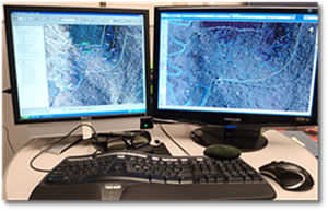 |
| Stereo monitors and shutter glasses allow Center botanists to view and map aerial photos in 3D. | |
Semi-automated waterfowl counts using object-based feature extraction software:
The Upper Mississippi River System (UMRS) is an important stopover for migrating waterfowl in the early-spring and late-fall. Aerial surveys are performed weekly during these visitations to determine the waterfowl species and approximate numbers as well as their preferred feeding habitat. Since 2003, digital aerial photography has been used to supplement these counts and provide precise numbers for selected areas and the vegetation make-up of feeding locations. Once aerial photos are georeferenced, they are converted to 1–bit images comprised of white dots (waterfowl) on a black background (water). Feature Analyst, an object-based feature extraction extension for ArcMap, is used to identify and count the white dots, or pixels, and generate a layer consisting of single points at the center of those pixels. This point layer can then be combined with similarly referenced vegetation and bathymetry layers to help determine resource usage patterns by vegetation types and water depths. For more information, please see the Waterfowl Counts web page.
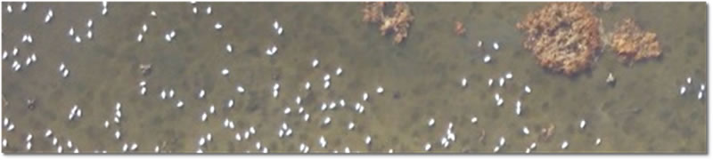 |
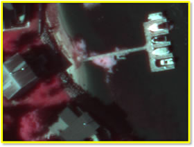
| Aerial photo detail of tundra swans feeding on tubers on Pool 8 of the Mississippi River. |
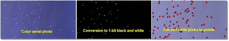 |
| Once photos are converted to 1-bit images, specialized GIS software can convert the white pixels to gereferenced points. |
Impact of UMESC Science
Implementing new technologies, when cost effective, allows UMESC to continue to increase both the production efficiency and spatial accuracy of its GIS data sets.
Points of Contact: Jennifer Dieck and Larry Robinson
Mention of trade names or commercial products does not constitute endorsement or recommendation for use by the U.S. Department of Interior, U.S. Geological Survey.

Page Last Modified: April 2, 2018