La Crosse
field station
La Crosse
field station
Vegetation
|
Aquatic vegetation is important for many reasons (poster).
Several monitoring methods have been or are being used at the Wisconsin
Department of Natural Resources Mississippi River Monitoring Field Station at La Crosse to monitor aquatic vegetation.
A summary of Pool 8 transect data can be found at the following
link: Pool
8 Transect Data Summary
Monitoring in the field (in the river or on the ground) includes:
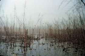
- A series of 45 fixed transects distributed among six contiguous
backwaters and two isolated backwaters were sampled for submergent
(underwater) vegetation from 1991-2000 following standardized
LTRMP procedures
for sampling submergent (underwater) vegetation manual #95-P002-3.
- Annually, between 70 and 80 informal sites (covering about 80%
of Pool 8) were surveyed qualitatively (1991-1997) for submergent
vegetation.
- Stratified random point-sampling (450-650 points throughout
different aquatic areas in Pool 8) was begun in 1998 to sample
submergent vegetation (see sampling design poster
and procedures
manual #95-P002-7 for details). This method replaced qualitative
sampling beginning in 1998.
|
Wild celery, a submersed aquatic plant monitored by the
field station, grows tubers that are valuable food for waterfowl
such as canvasback ducks. |
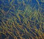
Crowsfoot is a submersed aquatic plant that blooms on the
surface.
(Photo by Andy Bartels) |
Monitoring with remote-sensing technologies (photos or images taken
from airplanes or satelites) includes:
- Color infrared aerial photos of Pool 8 are also taken annually
at peak biomass to assess coverage of terrestrial, floating leaf,
and emergent vegetation.
- True Color aerial photos of Pool 8 are taken at wider time intervals. Aerial photo mosaics are produced.
- The Wisconsin Field Station's vegetation specialist interpreted
the color infrared photos for floating leafed, emergent, and terrestrial
vegetation. Other employees funded by LTRM partners register
these data on base maps and digitize them to produce Land Cover/Land
Use maps. (See
procedures manual # 95-P008-2)
|
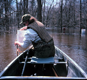
|
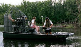
The WDNR La Crosse's vegetation crew uses the airboat to
get into shallow and weedy or otherwise inaccessible areas
during stratified random sampling for submersed vegetation. |
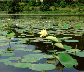
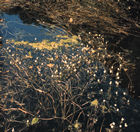
American Lotus is a common floating-leafed
plant which provides food for wildlife. We monitor it with
both aquatic vegetation (on the water) methods and remote sensing
(aerial photography) methods.
(Photo by Heidi Langrehr) |
|
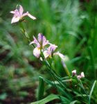
Arrowhead is a native plant that provides an important food
source for migrating waterfowl. We monitor emergent plants like arrowhead in the field and by remote sensing (aerial photography). |
Wild rice grows in several quiet backwaters
in Pool 8. It provides shelter and food for waterbirds and
is an important source of food for waterfowl during fall
migration. We monitor wild rice in the field and by interpreting aerial photography.
(Photos by Terry Dukerschein)
|
A research
project on floodplain forest regeneration examined seedling
growth and regeneration in floodplain forests with the eventual
goal being to model floodplain forest succession under varying
hydrological conditions. Two sites in Pool 8 contributed data
to this study, which was conducted at all six LTRM study
reaches from 1997—2000.
During spring floods, monitoring tree seedfall
on floodplain forest plots usually located on dry land can
be logistically challenging.
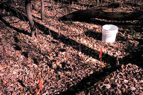
Seedfall, growth, and mortality/survival
data collected from this multi-year study will help scientists
predict floodplain forest composition and succession under
various flooding scenarios.
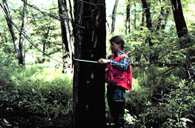
(Photos by Lisa Hodge Richardson and Heidi
Langrehr)
|
|
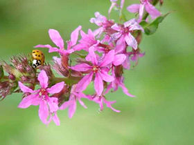
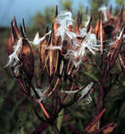
Two invasives -- an Asian ladybug investigates a flower of purple
loosestrife for small insect prey. Purple loosestrife is
an exotic emergent that has invaded from Europe. The ladybug
is not likely to find the jackpot—purple loosestrife
has few natural enemies and pests in North America and spreads
easily for that reason. It has no food value for most North
American wildlife and displaces plants that do have food
value. Field station personnel monitor purple loosestrife
by interpreting aerial photography.
(Photos by Terry Dukerschein)
|
|
More specific information needed to interpret LTRM data on submersed
vegetation can be found at the following link at the LTRM
Vegetation Data page.
La Crosse Field Station Team Leader
Telephone: (608) 781-6360
Fax: (608) 783-6066
Poster presentation available:
| Long Term Resource
Monitoring Sampling Methods |
|
| Aquatic Plants of the Upper
Mississippi River System |
|
Page Last Modified:
April 3, 2018