

Upper Midwest Environmental Sciences Center
U.S. Fish & Wildlife Service - Invasive Species
UMESC, in a cooperative effort with the USFWS, is also involved in several invasive species projects. Those projects are described below.
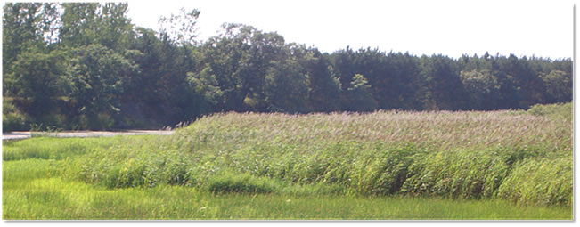 Reed Canary Grass Adaptive Management Project |
Invasive species present a challenge to the efforts of National Wildlife Refuges (NWRs) to preserve appropriate plant community habitat. Reed canary grass (Phalaris arundinacea, RCG) is an invasive plant species that presents such a challenge. This species has partially or heavily infested approximately 37,400 acres of NWRs located in U.S. Fish and Wildlife Service Region 3 (Midwest Region) and Region 6 (Mountain-Prairie Region). To improve management of RCG and assist in the recovery of degraded wet meadow and floodplain forest ecosystems within these NWRs, an adaptive management (AM) framework is being utilized.
The goal of this project is to generate the information needed for refuge managers to make good and defensible decisions about when, where, and how to treat RCG for purposes of maintaining or restoring target communities and the wildlife they support. Site-level information (hydrology, soil nutrient data) has been collected for 41 sites across 10 NWRs. Vegetation data has been collected and management (fluazifop or glyphosate herbicide) has been implemented for 3 years (2008, 2009, 2010). A spatially explicit Decision Tool has been developed for ArcGIS that uses these response data to predict outcomes of future herbicide treatments, and facilitate decisions based on these outcomes. USFWS participants continue to help build and refine the Decision Tool based on the anticipated needs for their refuges.
The final research-phase year of the project is 2011, during which we will learn about the effect of direct seeding native species into sites that have been managed for RCG. For more information, please visit the Reed Canary Grass Adaptive Management Project web site.
Impact of UMESC Science
To generate decision-making information needed for refuge managers on how to treat reed canary grass in order to maintain or restore target communities and the wildlife they support.
Point of contact: Erin Hoy
 Southern Indiana - Big Oaks & Muscatatuck National Wildlife Refuges |
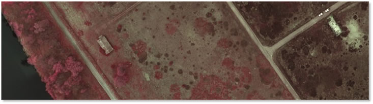
The U.S. Fish & Wildlife Service’s mission is to conserve the nation’s fish, wildlife, and plants. As resource managers of National Wildlife Refuges (NWRs), we have a responsibility to protect and conserve native habitats. Native ecosystems are constantly evolving as they are being negatively impacted by a multitude of non-native invasive species and become less diverse. The ability to rapidly detect, map, and control or eliminate non-native invasive plants has become a high priority for many NWRs. Due to their expansive areas, coupled with inaccessibility and challenging terrain, NWR managers and biologists often do not have the staff, time, or resources to consistently map invasive plants. Many NWRs are bordered by local and/or state interests or other private landowners. A concentrated effort to control invasives on refuges can be successful but not without the assistance of bordering neighbors who most likely have these same invasives on their properties. Partnerships with these proprietors are crucial, in order to control or eliminate invasive plants near or around NWRs.
Because of the lack of on-the-ground resources to efficiently map invasive plants, the use of remote sensing, such as digital aerial color infrared (CIR) photographs, to map key invasives can emerge as a powerful tool. The CIR photographs could detect specific invasive plants (at their ideal peak, compared to the surrounding native plants), detect invasions, assess infestation levels, monitor the rate of spread, and monitor efficiency of control efforts. The information from this study should provide guidelines to utilize aerial CIR photographs to map specific invasive plants, assist resource managers in the development and execution of their Integrated Pest Management (IPM) plans, and fulfill the overall mission of the U.S. Fish & Wildlife Service to conserve and protect native habitats. For more information on these refuges and related conservation planning, click the links below.
- Big Oaks National Wildlife Refuge
- Muscatatuck National Wildlife Refuge
- Muscatatuck NWR Comprehensive Conservation Plan
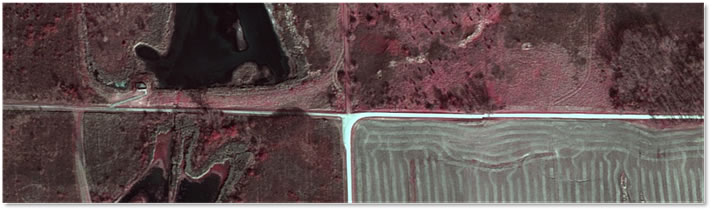
 Lost Mound Unit, Illinois – Upper Mississippi River National Wildlife and Fish Refuge |
The Lost Mound Unit was created when the USFWS accepted certain management rights and land from the former Savanna Army Depot, located along the Mississippi River in Illinois. Lost Mound Unit contains five thousand five hundred acres of forested backwaters and four thousand acres of rare sand prairie/ savanna. The area includes the longest natural dune system in Illinois and many threatened or endangered species use habitats on the site. Because of the reproductive success and rapid spread of invasive plants, an inventory is the first step in controlling their spread. In turn, this will protect native habitats and encourage plant diversity. Because of its former land use history, Lost Mound has many disturbed areas and these typically more open to encroachment by exotic invasive plants.
Because invasive species spread quickly and may be widely disbursed in rarely visited or hard to access areas, mapping their locations and extents with color infrared (CIR) aerial photography can help to provide a baseline of current conditions and how well their photo “signatures” are captured by a digital camera. This knowledge will help analysts and land managers adapt a program to detect, monitor and assess the efficacy of any treatment options on exotic invasive plants. This will also help the USFWS to fulfill its mission to conserve and protect native habitats. For more information, click the links below.
- Upper Mississippi River National Wildlife and Fish Refuge
- Lost Mound Unit Comprehensive Conservation Plan
Impact of UMESC Science
Invasive species present a challenge to the efforts of National Wildlife Refuges to preserve appropriate plant community habitat. This project will generate the information needed for refuge managers to 1) make good and defensible decisions about when, where, and how to treat invasives species for purposes of maintaining or restoring target communities and the wildlife they support, and 2) help develop the best remote sensing methods for detection and mapping of invasive species.
Component specialist: Larry Robinson
URL: http://umesc.usgs.gov/mapping/usfws_invasives.html
Page Contact Information: Contacting the Upper Midwest Environmental Sciences Center
Page Last Modified: March 4, 2011