|
|

HNA Summary Report
Existing
Conditions
Connectivity, Fragmentation,
and Diversity
|
|
Connectivity
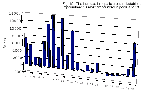
Seasonal flooding is an ecologically important process in large
river floodplain ecosystems because it connects the river with its
floodplain. In the UMRS many low elevation floodplain areas are
no longer subject to seasonal flooding because they are permanently
flooded from impoundment by navigation dams. Comparing pre-dam and
post-dam, total open water area has decreased or remained stable
in Pools 5a, 6, 14 to 25, the Open River, and the Illinois River,
but it increased in Pools 4, 5, 7 to 13, and 26 (Fig. 15).
|
|
|
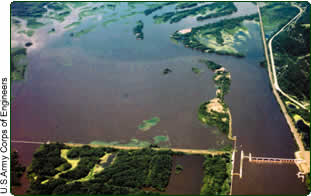
| Pool 5a clearly displays the impounded area and expanded
backwaters created by the dam. |
|
|
|
Stability implies that dams had little effect on the plan form outline
and amount of open water area. Decreases in water area are attributable
to several geomorphic processes including: loss of contiguous backwaters,
filling of isolated backwaters, loss of secondary channels, filling between
wing dams, and delta formation. Increases in water area are apparent where
dam impacts inundated significant amounts of low elevation floodplain
in lower pool areas.
|
 |
|
Connectivity of UMRS aquatic habitats has also been modified by dams
that block fish migration on the mainstem rivers and up into tributaries.
Flood control and hydroelectric dams block access to over one-half of
the length of tributary streams and rivers. Fish use tributaries for spawning
and to seek refuge from harsh flow or water quality conditions on the
main river. Upper Mississippi River System navigation dams are used to
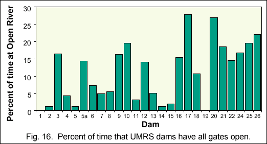
maintain low flow navigation, so the dams were constructed to allow high
flows to pass freely through the dams with all gates open. Locks and dams
1 and 19 present nearly complete barriers to upriver fish migration because
they are also hydroelectric dams with high fixed crests. The other dams
are open from 1 to 30 percent of the time, which provides some opportunity
for upriver fish passage (Fig. 16).
|
|
 Fragmentation
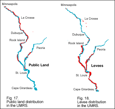
Natural habitats are highly connected south of Minneapolis to Clinton,
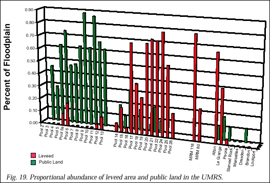
Iowa, because there is abundant public land (Fig. 17). However, discontinuity
in the distribution of public lands and levees (Fig. 18) has resulted
in significant habitat fragmentation south of Rock Island and along the
lower Illinois River (Fig. 19). The riparian forest remains fairly contiguous
in a narrow band along the longitudinal gradient of the rivers, but large
tracts of other native floodplain terrestrial communities only remain
as remnants in the national wildlife and fish refuges and state conservation
areas.
|
 |
|
Diversity
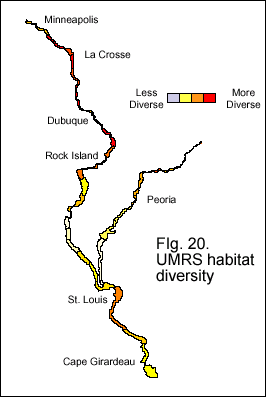 Habitat
diversity is a measure of the different types of habitats, their size,
and their relative abundance in a defined area. Habitat diversity can
be calculated for both land cover and geomorphic areas. Land cover diversity
is highest along Minnesota, Wisconsin, and northern parts of Illinois
and Iowa (Fig. 20). Pools 1 to 4, 14 to 19, and the Illinois River have
moderate diversity. Pools 1 and 15 are highly urbanized, Pool 18 and Alton
Pool are highly agricultural and have incomplete data. Pool 20 and southward
have the lowest Agriculture is an obvious low diversity environment but
even natural communities such as this sedge marsh can have few species.
A more diverse marsh supports many different types of herbaceous and woody
plants. diversity scores. These lower reaches are highly developed for
agriculture. Geomorphic area diversity follows a pattern very similar
to land cover diversity. Habitat
diversity is a measure of the different types of habitats, their size,
and their relative abundance in a defined area. Habitat diversity can
be calculated for both land cover and geomorphic areas. Land cover diversity
is highest along Minnesota, Wisconsin, and northern parts of Illinois
and Iowa (Fig. 20). Pools 1 to 4, 14 to 19, and the Illinois River have
moderate diversity. Pools 1 and 15 are highly urbanized, Pool 18 and Alton
Pool are highly agricultural and have incomplete data. Pool 20 and southward
have the lowest Agriculture is an obvious low diversity environment but
even natural communities such as this sedge marsh can have few species.
A more diverse marsh supports many different types of herbaceous and woody
plants. diversity scores. These lower reaches are highly developed for
agriculture. Geomorphic area diversity follows a pattern very similar
to land cover diversity.
|
|
|
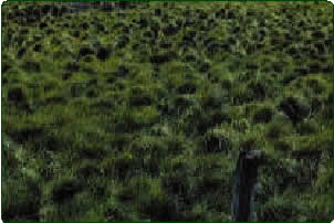
| Agriculture is an obvious low diversity
environment but even natural communities such as this sedge
marsh can have few species. |
|
|
|
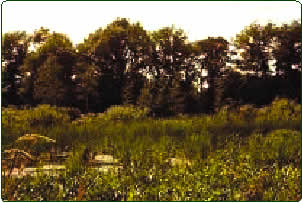
| A more diverse marsh supports many
different types of herbaceous and woody plants. |
|
|