

Upper Midwest Environmental Sciences Center
Predicting the Fate of Abandoned Agricultural Lands Along the Lower Missouri River
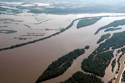
Embracing an abandoned floodplainFor hundreds of thousands of years, the Missouri River scoured and shaped the landscape across the western half of the United States. Characteristic of a large, unregulated floodplain river system, the main channel writhed within the floodplain – an ever-evolving mosaic of small braided channels, sloughs, islands, sandbars and backwaters. While the dynamic floodplain river ecosystem supported incredibly rich biodiversity, the extensive flooding would eventually interrupt human progress. In the mid-1900s, flood control measures – including dams and levees – were introduced to normalize flow and reduce flooding. The regulated river became easier to navigate, and the fertile floodplain land – no longer prone to inundation – was embraced for agriculture. In Missouri, agriculture persisted across much of the floodplain landscape until a massive flood in 1993 caused extensive and expensive crop damage. Farmers reconsidered their use of the floodplain and tens of thousands of hectares of agricultural land – much of it adjacent to the Big Muddy National Fish and Wildlife Refuge in Missouri, USA – were put up for sale. The U.S. Federal government purchased the abandoned land in order to expand the refuge and provide additional habitat for wildlife. From reclamation to restoration
|
|
|||
|
Methods
The research team selected seven study sites within the lower Missouri River alluvial floodplain that contained both wet prairie and early forest. At each site, they collected data related to a variety of environmental characteristics that are believed to influence the direction of ecological succession including:
- Flood frequency
- Soil drainage
- Distance from the main channel
- Elevation
Statistical modeling was used to relate the environmental variables to successional stage (wet prairie or early forest). Based on the analysis, the research team identified key characteristics that could accurately predict the potential successional direction of the abandoned floodplain lands acquired by the refuge.
The direction of succession
The predictions of how succession would shape the abandoned agricultural land were based on what is known about the successional dynamics on uncontrolled rivers with regular flooding events. However, this study reveals that the succession of plant communities within the floodplain of regulated rivers may not follow the same pattern. While it was expected that land closer in proximity to the main channel with similar elevation would succeed into wet prairie, the absence of regulated flooding events (characteristic of controlled rivers) allows these areas to develop into early forests. Conversely, moist soil sites further away from and at a higher elevation than the main channel are more likely to develop into to wet prairie habitat.
Contrary to predictions, early forest sites were closer to the river and at a lower elevation but occurred on drier soils than wet prairie. In a regulated river such as the lower Missouri River, wet prairie sites are largely isolated from the main channel compared to early forest, despite occurring on soils that are relatively moist.
Management implications
The models created in this study are a useful tool for predicting the relative benefit of land acquisition by natural resource agencies including the expansion and improvement of ecosystem services such as wildlife conservation. The ability to make accurate predictions related to ecological succession improves the outcomes of science-based conservation and management efforts – and are a crucial measure for promoting efficient and effective stewardship.
Adapted from:
Throgmartin, W.E., M. Gallagher, N.Young, J.J. Rohweder and M.G. Knutson. 2007. Factors associated with succession of abandoned agricultural lands along the lower Missouri River, U.S.A. Restoration Ecology 17:290-29 URL: http://umesc.usgs.gov/terrestrial/migratory_birds/abandoned_lands_lower_mississippi.html
Page Contact Information: Contacting the Upper Midwest Environmental Sciences Center
Page Last Modified: February 1, 2016