

Upper Midwest Environmental Sciences Center
Modeling the Distribution and Relative Abundance of Mammalian Predators in the Prairie Pothole Region of Minnesota
Mammalian predation is a major factor influencing waterfowl productivity in the Prairie Pothole Region. Rates of predation of waterfowl nests differ by predator species, so understanding landscape or spatial patterns in predator density are desired by many natural resource managers. Spatial predictions for the occurrence and relative abundance of predators would allow natural resource managers to make informed decisions when applying management treatments, greatly increasing the efficiency and effectiveness of those treatments. The primary objective of this study is developing statistical models and maps predicting the spatial patterns of primary nest predators in the Prairie Pothole Region of Minnesota. The sampled area encompasses 19,642 mi2. Systematic track surveys were conducted in 2003, 2004, and 2005. Building a ModelThese survey data of predator observations will be used as the response in hierarchical Bayesian spatial count models fitted with Markov chain Monte Carlo techniques in WinBUGS. Since surveys occur in blocks for which the response in one block is correlated with the responses in neighboring blocks, models will accommodate nuisance random effects associated with the survey design. Random effects associated with observer bias in their ability to detect tracks, day of year, and year will be considered. Fixed effects associated with the number of days since the last rain or strong wind, soil conditions and the number of available sites per survey block will also be evaluated.; These fixed effects are only available at the resolution of 16 mi2 (i.e., collected over an entire survey block). Explanatory covariates to aid in predicting patterns in predator abundance include the proportion of a block in grass, forest, emergent wetland, and road. |
|
Multiple models will be evaluated for each species by altering the number of fixed effects.; Models will be compared from an information-theoretic perspective by calculating a Deviance Information Criterion (DIC); this metric is comparable to Akaike’s Information Criterion.
For the models of raccoon and fox, a covariate associated with coyote occurrence will also be considered (to assess the hypothesis that coyotes reduce the abundance of raccoons and foxes through competitive exclusion). Further, in the models for skunk and fox, covariates for fox and skunk will be included, respectively (to assess whether fox and skunk co-associate). Lastly, models of predator species activity and richness will be calculated; the former uses as the response the sum of all observations within a survey block, whereas the latter uses as the response the sum of species observed within a survey block.Testing Models
Final models will be mapped at the resolution of the response (see below) and at the resolution of the finest environmental covariates. Models will be evaluated for their accuracy and bias by withholding 20% of the available observations, using the final model form to impute an expected observation, and then comparing expected versus observed with linear regression.
Current survey data available for the study area occurs in 16 mi2 (41.4 km2) plots. Spatial models resolved at this spatial resolution provide only a coarse perspective on the patterns of mammalian occurrence and relative abundance, constraining the ability of managers to effectively deliver actions for reducing predation on waterfowl nests. To assess the first objective will involve an evaluation of the potential for resolving historical survey data to resolutions considerably finer than 41.4 km2.
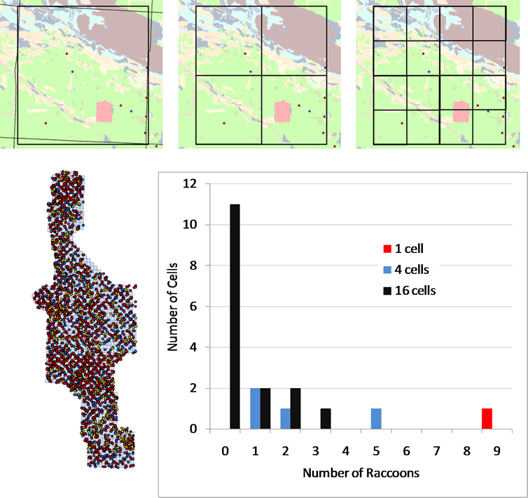
Figure 1. Schematic describing a) spatial distribution of all observations of raccoons in 2004 across full study area; 9 observations of raccoons in b) one 16-mi2 study block (i.e., a density of 0.56 raccoons per mile, 100% occupancy), c) 4 4-mi2 study blocks, ranging in density from 0.25 to 1.25 raccoons per mi2, 100% occupancy, and d) 16 1-mi2 study blocks, with observed density ranging from 0 to 3 raccoons per mi2, 31.25% occupancy. The histogram (e) of the number of raccoons/cell indicates an increasing skew toward a greater proportion of unoccupied cells as cell resolution becomes increasingly fine.
Impact of UMESC Science
Development of statistical models and maps that predict the spatial patterns of mammalian nest predators in the Prairie Pothole Region of Minnesota will help resource managers make better decisions about predator control and waterfowl management. If time allows, testing the model for accuracy and bias, will be made to determine the most effective resolutions (16 mi2, 4 mi2, or 1 mi2) for assessing predator populations in this region.
URL: http://umesc.usgs.gov/terrestrial/mammalian_predators_minnesota.html
Page Contact Information: Contacting the Upper Midwest Environmental Sciences Center
Page Last Modified: February 1, 2016