Upper Midwest Environmental Sciences Center
Decision Support Systems
Split By Attribute Tool
The Split By Attribute Tool is a customization of ArcMap 10. The tool takes a single shapefile and splits it into many shapefiles based on the unique values of a chosen field.
FoxSplitByAttributeAddin_10_1.zip
FoxSplitByAttributeAddin_10_2.zip
FoxSplitByAttributeAddin10_3_1.zip
FoxSplitByAttributeAddin10_5.zip
To install:
- Save the file: FoxSplitByAttributeAddin.zip to your local hard drive
- Extract contents
- Double click FoxSplitByAttributeAddin.esriAddIn file
- Open ArcMap 10
- Click on the Customize menu and the Customize Mode… item
- On the Customize dialog click the Commands tab
- Scroll down and click on Fox Tools in the Categories list
- Drag the Split By Attribute button to a toolbar on the ArcMap 10 interface
|
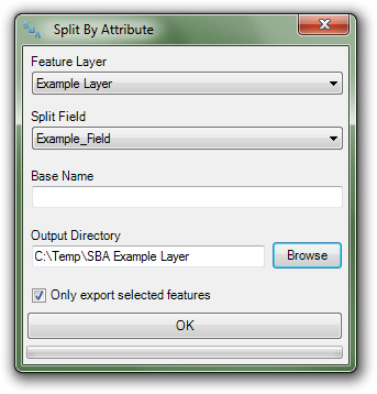 |
| Figure 1. The Split By Attribute dialog. |
|
To use:
- Click the Split By Attribute button to open the Split By Attribute dialog (Figure 1)
- Choose a Feature Layer to split into component layers
- Choose a Split Field whose unique values will be used as the basis of the split
- Optional: enter an Optional Output Prefix, this value will added to the name of all of the output layers
- Click the Browse button and identify the output directory. The tool will create a folder and file geodatabase with the following structure: User identified directory + \SBA + Layer Name + Iterative Number (as needed)\SBA.gdb
- Check the Only export selected features checkbox if you want to restrict the export operation to selected features
- Click OK button
- Program execution:
- The file geodatabase specified in the Output Directory is created
- Unique values from the chosen field are retrieved from the feature class
- The program iteratively queries the feature class for each unique value in the split field and exports the resulting selection to the file geodatabase. Each layer will named with the following structure: Optional Output Prefix + Split Value (Figure 2)
|
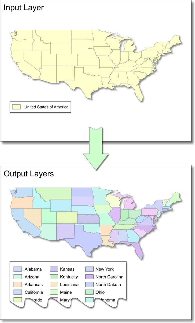 |
| Figure 2. An example of an input layer split on the State_Name field and the resulting output layers. |
Impact of UMESC Science
Split by attribute is a GIS tool that provides functionality not inherent to ArcMap 10. This tool provides a service of efficiency to geospatial analysts.
Point of contact: Tim Fox
|
URL: http://umesc.usgs.gov/managment/dss/split_by_attribute_tool.html
Page Contact Information:
Contacting the Upper Midwest Environmental Sciences Center
Page Last Modified:
December 1, 2017


