

Upper Midwest Environmental Sciences Center
Dabbling Duck Models
Models depicting dabbling duck habitat were created by the Upper Midwest Environmental Sciences Center (UMESC) to help facilitate planning for a subunit of a Habitat Rehabilitation and Enhancement Project (HREP) scheduled for construction in Pool 8 of the Upper Mississippi River. The UMESC was contacted by the U.S. Fish and Wildlife Service (USFWS) refuge manager of this area (Jim Nissen) and asked to help create a set of models for the proposed project. The models that were constructed captured the expert opinions of the U.S. Geological Survey, USFWS, and U.S. Army Corps of Engineers (USACE) personnel; they are not statistical models.
|
|
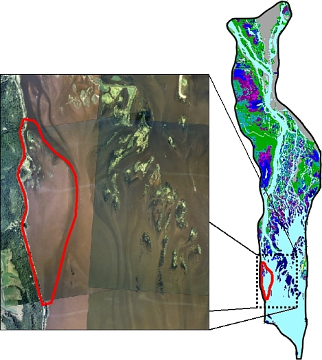
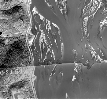
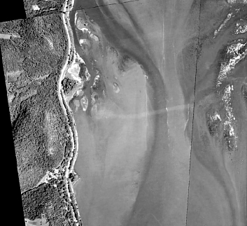
The proposed HREP is located on the western shoreline of the impounded area of Pool 8 (Figure 1). The impounded portion of Pool 8 has lost many of its island structures and associated vegetation that are illustrated in Figures 2 and 3. Compare the island structures visible in 1954 photography to structures visible in 1999 photography (Figures 2 and 3). The proposed HREP was to recreate some of the lost island structure. The USFWS wanted to see the islands created to optimize habitat for shallow-water birds (specifically concentrating on migrating marsh ducks). |
|
|
(click for larger image) |
(click for larger image) |
|
Experts from USFWS refuge staff, UMESC, and USACE held a workshop and created an outline for a Pool 8 dabbling duck model. The model focused on the following elements:
- Emergent plant growth
- Submergent growth
- Feeding bathymetry
- Loafing bathymetry
- Loafing structure
- Protection from disturbance
- Thermal protection
- Protection from wave action
|
 Figure 5. Final model output (click for larger image) |
The UMESC created new topographic layers based on eight alternative island layouts provided by USACE (Figure 4). The derived layers depicted what the land and riverbed surfaces might look like under each of the eight scenarios provided by USACE. The topographic layers are the driving force behind the model output. The final model output shows a dabbling duck suitability surface for the project area. The scores range from zero to eight, with a score of zero being marginal habitat and eight being prime habitat (Figure 5). From these outputs we can summarize the change in habitat relative to existing conditions and use this analysis in a rudimentary cost-benefit analysis (Figure 6). 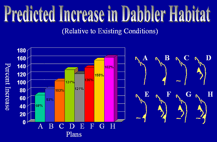 Figure 6. Predicted increase in dabbler habitat (click for larger image) |
|

These models were used to aid communication between USFWS management and USACE engineers and planners. The models helped both partners envision the issues being discussed with graphical and quantitative spatial support. They also illustrated UMESC's ability to quickly respond and produce to a model according to the users' need.
The project was completed in September 2001.
Impact of UMESC Science
The dabbling duck models were conceived in a workshop that brought together land managers, engineers, and biologists. The spatial models helped evaluate island configurations for a habitat restoration project on the Upper Mississippi River.
Principal Investigator: Tim Fox
URL: http://umesc.usgs.gov/management/dss/5004778_duck_models.html
Page Contact Information: Contacting the Upper Midwest Environmental Sciences Center
Page Last Modified: March 1, 2011