Dot gov

The .gov means it’s official.
Federal government websites often end in .gov or .mil. Before sharing sensitive information, make sure you’re on a federal government site.

Https

The site is secure.
The https:// ensures that you are connecting to the official website and that any information you provide is encrypted and transmitted securely.

Upper Midwest Environmental Sciences Center

folder.gifRiver Inventory and Monitoring
tree_f.giffolder.gifBathymetry
 tree_f.giffolder.gifExamples of studies utilizing bathymetric data

Suitable Backwater Over-wintering Habitat

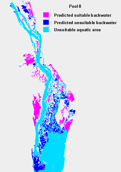
A predictive GIS model is being developed that uses morphometric characteristics to anticipate the likelihood of a backwater being suitable for over-wintering of fishes. Water depth is used both to determine physical space available and to determine water exchange rates that influence water temperature and dissolved oxygen levels. Below is an example of the output of the GIS model.  Principal investigator: Jim Rogala.
Suitable backwater over-wintering habitat (map)

Additional documentation regarding suitable backwater over-wintering habitat

November 17, 2000

Accessibility FOIA Privacy Policies and Notices

Take Pride in America logo USA.gov logo U.S. Department of the Interior | U.S. Geological Survey
URL: http://umesc.usgs.gov/aquatic/bathymetry/examples/suitable.html
Page Contact Information: Contacting the Upper Midwest Environmental Sciences Center
Page Last Modified: January 29, 2016