
Terrestrial Wetland Global Change Research Network
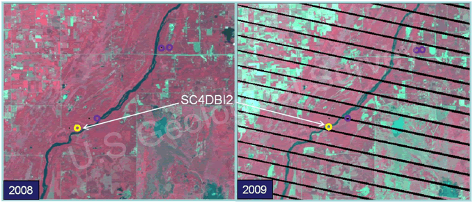
Fig. 12a. Images indicating relative dryness for a portion of the landscape around site SC4DBI2 in the St. Croix National Scenic Riverway. The 2008 image was produced from Landsat-5 data collected during August and the 2009 image was produced from data collected from Landsat-7 during July. The areas of brighter bluish-green color in 2009 indicate less standing water, less vegetation, and less vegetation moisture than in 2008. The parallel black lines in the 2009 image are artifacts of an equipment failure on board Landsat-7. The three small circles near the river are additional sites we have instrumented on the ground.
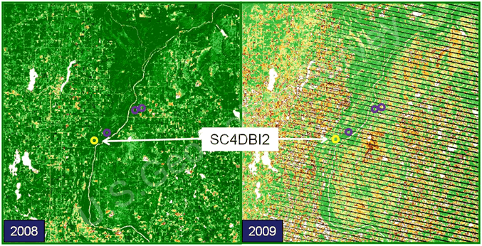
Fig. 12b. Images of the Normalized Difference Vegetation Index (NDVI) for the same landscape portion shown in Fig. 10a produced from data from the same satellites at the same time. More green indicates more photosynthetic activity. The differences in vegetation between the two years were associated positively with the relative dryness shown in Fig. 10a.
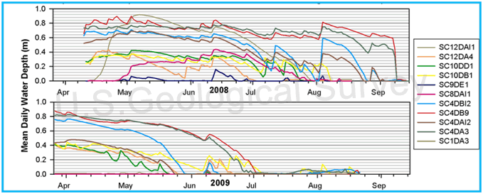
Fig. 12c. Water levels (at the deepest location) for ten wetlands we monitored from the ground in the St. Croix National Scenic Riverway in 2008 and 2009, including site SC4DBI2 shown in Figs. 10a and b. Each line represents water levels for that wetland over the course of the reproductive season. Water levels were recorded every hour of every day during deployment via submersible water-level loggers. Water levels at the wetland scale showed similar general trends across 2008 and 2009 as relative dryness (Fig. 10a) and NDVI (Fig. 10b) at the landscape scale.

Fig. 12d. Soundscapes produced from acoustic data we collected with digital sound recorders at site SC4DBI2 in the St. Croix National Scenic Riverway in 2008 (left) and 2009 (right). Graphs depict mean decibel levels (colored contours) plotted against frequency range (y axis) and day (x axis) for site SC4DBI2 from May 15-June 30. The colored contours represent sounds made by amphibians and birds primarily. The reduced calling activity and sound intensity in 2009 were associated with reduced water present in the wetland and the surrounding landscape (Fig. 10a, b, c). Eastern and Cope’s gray treefrogs and green frogs, for example, called less at SC4DBI2 during this time period in 2009 compared to 2008.
| St. Croix National Scenic Riverway | |||||||||||
Late night sounds at this site in the St. Croix National Scenic Riverway on May 31, 2008 (site contained standing water and amphibians were calling).
|
Click here to listen to late night sounds at this site in the St. Croix National Scenic Riverway on May 31, 2009 (site was dry due to drought conditions and no amphibians were calling).
|
||||||||||
Page Last Modified: April 3, 2018