Illinois River - Select a Reach
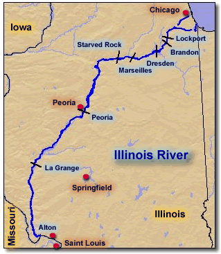
The reach and pool pages are used to access Web pages that contain links to aerial photographs, GIS data, and project information. The reaches themselves are used to describe areas of similar geomorphology, vegetation cover, and land use practices and to describe portions of the Illinois River. For example, La Grange is the area upstream of the La Grange Lock and Dam, extending to the Peoria Lock and Dam.
| Alton | Brandon | |
|
Alton is used to describe the unimpounded portion of the Illinois River. It extends from the Mississippi River upstream to the La Grange Lock & Dam south of Beardstown, Illinois. |
Brandon extends from the Brandon Lock & Dam located within Rockdale and Joliet, Illinois, upstream to the Lockport Lock & Dam located near Lockport, Illinois. | |
| Dresden | La Grange | |
|
Dresden extends from the Dresden Lock & Dam located south of Channahon, Illinois, upstream to the Brandon Lock & Dam, in Rockdale and Joliet, Illinois. |
La Grange extends from the La Grange Lock & Dam located south of Beardstown, Illinois, upstream to Peoria Lock & Dam located near Peoria, Illinois. | |
| Lockport | Marseilles | |
|
Lockport extends from the Lockport Lock & Dam located near Lockport, Illinois, upstream to the Chicago Harbor Lock, in Chicago, Illinois. |
Marseilles extends from the Marseilles Lock located near Marseilles, Illinois, upstream to the Dresden Lock & Dam located south of Channahon, Illinois. | |
| Starved Rock | ||
| Peoria extends from the Peoria Lock & Dam located near Peoria, Illinois, upstream to the Starved Rock Lock & Dam located near Utica, Illinois. | Starved Rock extends from the Starved Rock Lock & Dam located near Utica, Illinois, upstream to the Marseilles lock located near Marseilles, Illinois. |
Page Last Modified: April 17, 2018


