
|
PSR 99-10 November 1999 Recent Sedimentation Rates behind Constructed Islands in Lake Onalaska, Pool 7, Upper Mississippi River Systemby Pete J. Boma |
||
|
Since impoundment of the Mississippi River in the late 1930’s,
resource managers have been concerned about a reduction of habitat
diversity in backwaters of the Upper Mississippi River System. Lake
Onalaska, a backwater in lower Pool
7 with a mean depth of 1.3 meters, consists of open water, islands
and channels. Flow patterns and summer wind/ wave action create
a situation where fine sediments are transported through this 2,800-hectare
backwater lake. In an attempt to improve water clarity, lessen wind/wave
induced erosion and create backwater habitats, three crescent-shaped
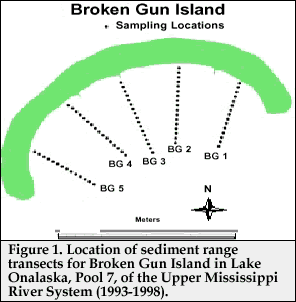
islands (Arrowhead, Broken Gun Bed elevation change was measured at 249 locations for each time period. There were sixteen occurrences, almost always near shore, when the yearly accumulation or erosional rate was greater than 10 cm. These high rates may have been caused by shoreline sluffing or human disturbance and were not included in the data set. |
||
|
||
|
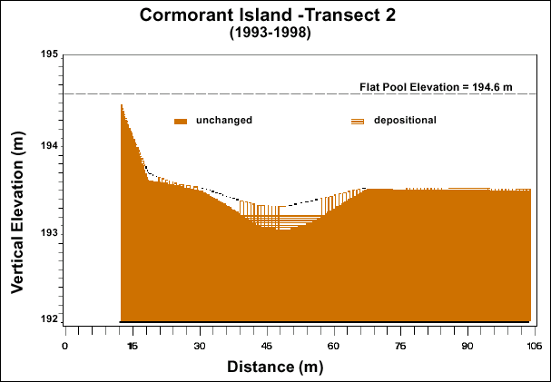
Mean sedimentation rates were calculated for each transect and for each island. For the period of record (1993-1998), Arrowhead, Broken Gun and Cormorant Islands had mean sediment accumulation rates of 1.60, 1.08, and 0.63 cm/yr and mean water depths of 1.38, 1.42 and 0.88 m, respectively. All yearly time periods for each island showed net sediment accumulation except for Cormorant Island in 1993, which showed a net erosional rate of -0.27 cm/yr (Figure 2). Some of the lowest net sedimentation rates for Arrowhead (0.51 cm/ yr), Broken Gun (0.72 cm/yr) and Cormorant (0.09 cm/yr) Islands were produced during 1995, possibly the result of it being a relatively low water year. Arrowhead transect 2 had the greatest mean water depth (1.57 m) and also the highest net sediment accumulation rate (2.32 cm/yr) for the period of record. Conversely, Cormorant transects 3 and 4 had the shallowest mean water depths of 0.53 m and 0.5 m and had net erosional rates for the period of record at -0.04 cm/y r and -0.69 cm/yr, respectively. They were also the only transects found to have net erosion for the period of record and were the only transects with an average water depth of less than 1 meter. For the fifteen transects over the six yearly time periods calculated, net erosion occurred fifteen times, with most of the erosional time periods occurring behind the shallower Cormorant Island. One of the locations with the highest accumulation rates (4.62 cm/yr) occurred on Cormorant transect 2 (Figure 3). This transect differed from the other transects in that there was a 46 cm depression present in 1993. By 1998, the depression was reduced to 21 cm by sediment accumulation. |
||
|
||
|
The sheltered zones behind the constructed islands efficiently trapped sediments, as evidenced by the relatively high sedimentation rates observed, and also created more diverse habitat, as verified by bathymetric surveys. Apparently, water depth played a role in sedimentation rates and transects that were less than 1 m deep had changes suggesting that sedimentation had reached some sort of equilibrium. We also found that sediment focusing (transport of sediment from shallow areas to deeper areas) occurred along Cormorant transect 2. Monitoring will continue to accurately predict the future conditions of the sheltered zones behind the constructed islands. |
||
|
This report is a product of the Long Term Resource Monitoring Program for the Upper Mississippi River System. For further information, contact Pete J. Boma Project Status Reports (PSRs) are preliminary documents whose purpose is to provide information on scientific activities. Because PSRs are only subject to internal peer review, they may not be cited. Use of trade names does not imply U.S. Government endorsement of commercial products. All Project Status Reports are accessible through the Upper Midwest Environmental Sciences Center’s website at http://umesc.usgs.gov/reports_publications/psrs/umesc_psr.html |
 and Cormorant) were constructed in Lake Onalaska by the
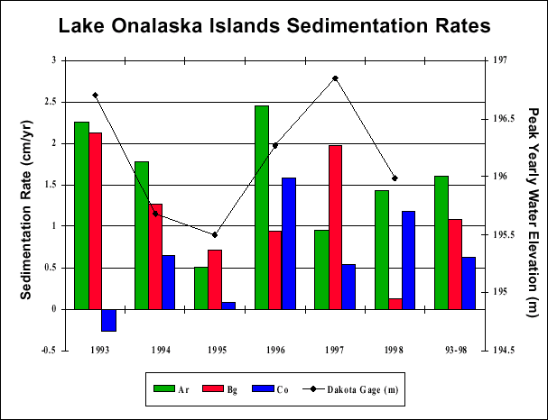
Page Last Modified: April 17, 2018