|
PSR 99-08 September 1999 Landscape Patterns along the Upper Mississippi Riverby Mary R. Craig |
||
|
The corridors of large-river floodplain ecosystems, like the Upper Mississippi River (UMR), are important conduits for the movement of water, minerals, nutrients, and species. In riverine landscapes, where physical and biological processes are closely linked, alterations in landscape structure have the potential for not only affecting the dynamics of water and sediment routing and delivery but of also affecting the population dynamics of cross-continental migratory species. The ability of any large-river floodplain ecosystem to function as a corridor is largely dependent upon the pattern of landscape structure along the river’s course. Despite the importance of riverine systems as movement corridors, longitudinal (source to mouth) patterns in landscape structure have not been quantified for any large-river floodplain ecosystem. The objective of this research, which is being conducted as part of the Long Term Resource Monitoring Program, is to quantify and analyze longitudinal differences in landscape structure along the Upper Mississippi River. The study area extends from River Mile 830, just downstream of St. Paul, Minnesota, to River Mile 0 at Cairo, Illinois. The lateral (horizontal) boundaries of the study area are the bases of the river’s valley walls. |
||
|
||
|
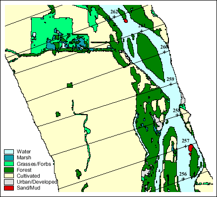
Geographic information system (GIS) coverages of land cover, derived from 1989 Landsat Thematic Mapper data and classified to seven categories (water, marsh, grasses/forbs, forest, sand/mud, urban/developed, and cultivated) were used in this analysis. The coverages were divided into smaller segments by perpendicularly splitting them at 1-mile intervals along the long axis of the river valley (Figure 1). For each river segment, FRAGSTATS (McGarigal and Marks, 1994), a spatially-oriented statistical program, was used to calculate measures of landscape structure in three general categories: landscape composition (the relative proportions of land cover), landscape configuration (the spatial arrangement of land cover within landscapes), and measures of patch shape. |
||
|
||
|
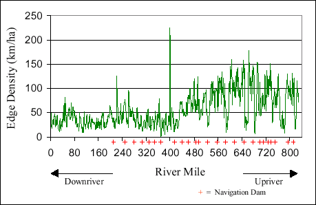
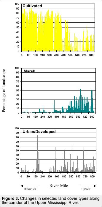
Changes in the measures of landscape structure are being traced
along the course of the UMR (Figures 2 and 3). The resulting graphs
reveal repetitions in longitudinal patterns of landscape structure,
as river segments and navigation pools tend to be most similar to
their immediate neighbors. Figure 2, for example, shows that patterns
of edge density (km/ha) among upper navigation pools (Pools 3 through
13) are self-similar. River segments for the lower portions of this
set of pools have low edge density while the middle and upper portions
have greater edge density. The analyses, however, are also revealing
overarching trends in landscape structure along the UMR. Refuge managers have used some of the results of these analyses at public meetings, and the analytical techniques developed in this research are being used in the development of Decision Support System applications for Upper Mississippi River System resource managers. The analytical approaches developed in this study have further application for assessing habitat needs and are being adopted for the Upper Mississippi River Habitat Needs Assessment (HNA). |
||
|
This report is a product of the Long Term Resource Monitoring Program for the Upper Mississippi River System. For further information, contact U.S. Geological Survey Project Status Reports (PSRs) are preliminary documents whose purpose is to provide information on scientific activities. Because PSRs are only subject to internal peer review, they may not be cited. Use of trade names does not imply U.S. Government endorsement of commercial products. All Project Status Reports are accessible through the Upper Midwest Environmental Sciences Center’s website at http://umesc.usgs.gov/reports_publications/psrs/umesc_psr.html |
Page Last Modified: April 17, 2018


 For
example, Figure 3 shows that the proportions of cultivated land
and marsh found within river segments are inversely related to one
another along the river’s length. Landscapes of upper river
reaches have greater proportions of marsh and lower proportions
of cultivated land than the intensively cultivated landscapes of
lower river reaches. And, although the landscapes of upper reaches
of the Upper Mississippi River proportionally contain more marsh,
they are also more urbanized than the landscapes of lower reaches.