
|
PSR 99-04 May 1999 The Upper Midwest Gap Analysis Programby Daniel J. Fitzpatrick |
||
|
The Gap Analysis Program (GAP) is a United States Geological Survey project being implemented nationwide with the help of more than 400 cooperators, including nonprofit organizations, the private sector, and other government agencies. The purpose of GAP is to identify “gaps” in the network of conservation lands with respect to land cover or habitat types as well as individual species, and to build partnerships around the development and application of this information. The intent is to provide focus and direction for proactive land management activities at the local, watershed, and basin-wide landscape levels. In 1995, the Upper Midwest Gap Analysis Program (UMGAP) was simultaneously initiated in Michigan, Minnesota and Wisconsin under the coordination of the Environmental Management Technical Center (EMTC) in Onalaska, Wisconsin. The EMTC has since become part of the Upper Midwest Environmental Sciences Center (UMESC), and Illinois has since joined the regional partnership. The UMESC also coordinates closely with state GAP efforts in Iowa and Indiana. The objectives of UMGAP are listed in the Table. |
||
|
|
||
|
The UMGAP is organized to avoid duplicating efforts while meeting the diverse information needs of the participating state and federal partners and cooperators. Towards this goal, the UMESC has established Cooperative Agreements with each participating state to develop land cover maps and public ownership maps. In Illinois, the State’s Natural History Survey is responsible for all GAP components. The states are implementing a uniform image processing protocol that will retain the full 30-meter resolution of Landsat Thematic Mapper (TM) satellite imagery. The protocol involves the use of ancillary data layers, including ecoregion boundaries, urban boundaries, and upland/ lowland masks to help stratify the TM images prior to processing. The intent is to limit variation within cover types during the classification process, resulting in higher land cover accuracies. |
||
|
||
|
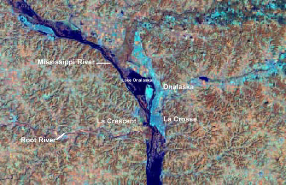
Staff at the UMESC are cooperating with Dr. Nancy Mathews, Ecology Department at the University of Wisconsin-Madison, and the U.S. Forest Service’s Great Lakes Assessment to produce maps of animal distribution, based in part on the land cover layer, and implement Gap Analysis and other biodiversity assessment studies. Stewardship maps will describe both land ownership and the conservation management level, or degree of intent to maintain biodiversity. Overlaying the animal distribution maps with the stewardship maps will reveal the “gaps” in important habitats being managed for long-term biodiversity. Though the Gap Analysis Program is producing land cover maps, public ownership maps, and animal distribution maps specifically in order to perform “gap” analysis, these data will also prove valuable to resource managers and planners responsible for the Upper Mississippi River System (UMRS) as they try to understand and respond to basin-wide processes that affect the UMRS and its floodplain. In addition to the primary UMGAP products, resource managers can also take immediate advantage of the very large inventory of Landsat Thematic Mapper satellite imagery that the UMESC and state partners are archiving. Among the potential products that can be extracted from the satellite data are georeferenced false color infrared images that can be used as backdrops to GIS coverages. The figure is an example of such a product. As regional GAP Coordinator, the UMESC has the expertise and ability to process and manage large amounts of remotely sensed data, and can manage and distribute the spatial data bases being generated by the state partners. By using the regionally consistent UMGAP data sets, natural resource managers will be able to develop ecologically sound conservation strategies for the entire Upper Mississippi River Basin, avoiding the difficulties commonly associated with combining data from multiple states or programs. |
||
|
This report is a product of the Long Term Resource Monitoring Program for the Upper Mississippi River System. For further information, contact Daniel
J. Fitzpatrick Dr. Erwin Klaas Dr. Patrick Brown Dave Heinzen Tim Weiss Project Status Reports (PSRs) are preliminary documents whose purpose is to provide information on scientific activities. Because PSRs are only subject to internal peer review, they may not be cited. Use of trade names does not imply U.S. Government endorsement of commercial products. All Project Status Reports are accessible through the Upper Midwest Environmental Sciences Center’s website at http://umesc.usgs.gov/reports_publications/psrs/umesc_psr.html |
Page Last Modified: April 17, 2018