
|
PSR 99-03 Revised February 2001 Spatial Data Query and Visualization Tool for Analyzing Upper Mississippi River System Data Sets - Beta 2.0by Douglas A. Olsen |
|
Collecting, storing and distributing data for water quality, fisheries,
invertebrate, vegetation, and other biological and physical data
on the Upper Mississippi River System (UMRS) are functions of the
Upper Midwest Environmental Sciences Center’s (UMESC) Long
Term Resource Monitoring Program (LTRMP). We are employing multiple strategies to get LTRMP data into the
hands of users. Our first Spatial Query Tool, developed on a UNIX
computer platform, had to be implemented as a macro language application
needing geographic information systems (GIS) software (e.g., ARC/INFO,
ArcView) to run the program. Our next primary strategy, to develop
stand alone desktop applications for Microsoft Windows 98, NT-4,
and 2000, will provide users with viewing and querying capabilities
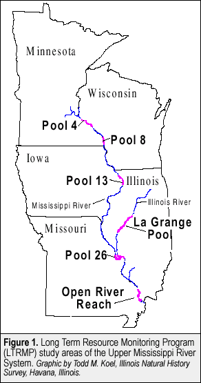
for a vast array of UMRS spatial data sets at a variety of scales. The first module being released for beta testing contains component
data (i.e., water quality, fisheries, and invertebrate) collected
from fixed and stratified random sites in each of the LTRMP study
pools: 4, 8, 13, and 26, of the Upper Mississippi River; the Open
River Reach on the Mississippi River near Cape Girardeau, Missouri;
and La Grange Pool of the Illinois River near Havana, Illinois (Figure
1). Our approach creates a completely compiled program that requires
no additional software to run. The development software used to
create this tool was Microsoft Visual Basic 6, and ESRI’s (Environmental
Systems Research Institute, Inc.) Map Objects class library.
The Spatial Query Tool (Figure 2) |
|
Summary This module is the first in a series that will comprise a LTRMP Spatial Data Query and Visualization Tool desktop application. We believe an easy-to-use display and query tool for Windows 98, NT-4, and 2000 will give users GIS display and query functionality. It is important to note that the Spatial Query Tool uses standard ESRI shapefiles that are compatible with ArcView as its data source. It would be a simple matter to use the data included with the desktop tool to build an ArcView project should the need for full-featured GIS functionality be required. User feedback will be essential to ensure that these tools are useful. If you are interested in evaluating or testing this beta module, we can ship the product on CD or it can be downloaded from our Home Page (http://umesc.usgs.gov/) under available data/geospatial applications. |
|
This report is a product of the Long Term Resource Monitoring Program for the Upper Mississippi River System. For further information, contact Project Status Reports (PSRs) are preliminary documents whose purpose is to provide information on scientific activities. Because PSRs are only subject to internal peer review, they may not be cited. Use of trade names does not imply U.S. Government endorsement of commercial products. All Project Status Reports are accessible through the Upper Midwest Environmental Sciences Center’s website at http://umesc.usgs.gov/reports_publications/psrs/umesc_psr.html |
 In
addition, spatial data (e.g., landcover/landuse, bathymetry, water
control infrastructure, human use facilities, and ecologically sensitive
areas) are collected, maintained, and stored in
In
addition, spatial data (e.g., landcover/landuse, bathymetry, water
control infrastructure, human use facilities, and ecologically sensitive
areas) are collected, maintained, and stored in 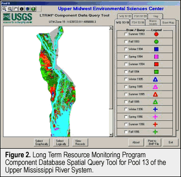 integrates the LTRMP component data with spatial data layers and
allows the user to overlay sampling point locations on basemap layers
(e.g., land/water, landcover/landuse, and USGS quadrangles) and
graphically or logically select sampling sites and their corresponding
records. The application features an easy-to-use interface and requires
only basic computer knowledge. The user can pan and zoom, turn on
and off basemap and sampling site layers, save images in the Windows
bitmap (.BMP) format, and output selected database records to an
ASCII file for analysis in other applications.
integrates the LTRMP component data with spatial data layers and
allows the user to overlay sampling point locations on basemap layers
(e.g., land/water, landcover/landuse, and USGS quadrangles) and
graphically or logically select sampling sites and their corresponding
records. The application features an easy-to-use interface and requires
only basic computer knowledge. The user can pan and zoom, turn on
and off basemap and sampling site layers, save images in the Windows
bitmap (.BMP) format, and output selected database records to an
ASCII file for analysis in other applications.Page Last Modified: April 17, 2018