|
PSR 99-02 February 1999 Vegetation Changes in Backwaters of Navigation Pools 4 and 13 of the Upper Mississippi River, 1975 to 1996by Jennifer J. Dieck and Robin W. Tyser |
||
|
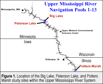
Since the impoundment of the Mississippi River in the late 1930’s, resource managers have been concerned about a reduction in habitat diversity in the Upper Mississippi River System due to sedimentation. Considerable attention has been focused on the accumulation of sediment and its possible effects on aquatic resources in the Upper Mississippi River (UMR). For example, loss of water depth provides an opportunity for rooted aquatic vegetation to colonize open waters that were originally too deep to support them. Plants, in turn, accelerate the accumulation of sediment by slowing water velocity. Successional changes, including a loss of open water and submersed vegetation and an increase in emergent and terrestrial vegetation, have been observed in Pool 19. However, lower rates of sedimentation have been observed in backwater areas of Pool 7 and Pool 8 of the UMR. This indicates that the accumulation of sediment may be less problematic in some areas. |
||
|
Other factors that may affect aquatic vegetation on the UMR include
drought, flood, and Habitat
Rehabilitation and Enhancement Projects (HREPs). These factors
have the potential to benefit or adversely affect the growth of
aquatic vegetation. |
||
|
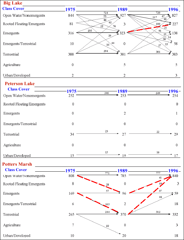
Color infrared aerial photographs from 1975, 1989, 1991-1994, and 1996 were used to examine changes in vegetation. The photographs were interpreted, transferred, and digitized. Digital coverages were then prepared and analyzed with UNIX ARC/INFO and ArcView software packages (ESRI, Redlands, California) and classified into seven general cover classes. Landscape transition matrices were constructed from the seven general cover classes and were used to determine replacement patterns among the cover classes over time (Figure 2). |
||
|
||
|
Results of the study indicated that vegetation succession occurred in Potters Marsh from 1975 to 1989. During this period, open water/nonemergent vegetation was replaced by emergent vegetation, and emergent vegetation was replaced by terrestrial vegetation. Areas occupied by open water/nonemergent vegetation in this site regained much of what was lost from 1989 to 1996, likely a result of the HREP activities occurring from 1994 to 1996. In the other two sites (Big Lake and Peterson Lake), successional changes were not observed. For example, in Big Lake, the amount of open water increased from 211 ha in 1975 to 286 ha in 1996. Also, 100 ha of emergent vegetation in 1989 were replaced by rooted-floating/emergent vegetation in 1996. In Peterson Lake, there was a 28% decrease in woody vegetation between 1975 (25 ha) and 1996 (18 ha). The area of the other cover classes in Peterson Lake remained fairly constant. Vegetation diversity in each of the three study sites remained fairly stable, even though each site was subject to different hydrological regimes. Also, the flood of 1993 did not increase diversity in the study sites as it did in other areas of the river, such as in Pool 8 (R. Tyser, unpublished data). Reasons for such differences in flood-related effects among pools require additional investigation. The construction of HREPs occurred between 1993 and 1996 at each of the study sites. However, even though the HREP in Potters Marsh caused immediate effects in vegetation, there has been insufficient time to detect any long term effects the HREPs may have had on plant communities. Therefore, we could not ascertain the effect, if any, that HREPs had on aquatic vegetation. Within the next 5 to 10 years, there should be clear indications of the effects of HREPs. |
||
|
This report is a product of the Long Term Resource Monitoring Program for the Upper Mississippi River System. For further information, contact Jennifer J. Dieck Robin W. Tyser Project Status Reports (PSRs) are preliminary documents whose purpose is to provide information on scientific activities. Because PSRs are only subject to internal peer review, they may not be cited. Use of trade names does not imply U.S. Government endorsement of commercial products. All Project Status Reports are accessible through the Upper Midwest Environmental Sciences Center’s website at http://umesc.usgs.gov/reports_publications/psrs/umesc_psr.html |
Page Last Modified: April 17, 2018


 For
example, flood pulses in large river floodplain systems may help
rejuvenate aquatic plant communities. However, the effects of flooding
may also cause aquatic vegetation to become buried by sediment or
uprooted by increased river velocity.