
|
PSR 98-08 September 1998 An In-situ Sediment Penetrometer for the Characterization of Sediment Type and Bottom Dynamic Conditionsby Robert F. Gaugush |
|
Since impoundment of the Mississippi River in the late 1930’s, resource managers have been concerned about a reduction of habitat diversity in backwaters of the Upper Mississippi River System (UMRS) due to sedimentation. As part of a 1989 Habitat Rehabilitation and Enhancement Project, three crescent-shaped islands were constructed in the lower portion of Pool 7 on the Upper Mississippi River (Lake Onalaska) to reduce wind fetch and wave action in the central region of this large, shallow, backwater lake. Personnel from the Environmental Management Technical Center (EMTC) conducted a sediment survey to determine if constructed islands in Lake Onalaska had an effect on sediment distribution, implying that the near-bottom dynamic conditions had been altered by island construction. Sediment deposition varies according to sediment type (particle size distribution, bulk density, moisture content, and organic content) and bottom dynamic conditions (the prevailing hydrodynamic conditions that lead to sediment erosion, transportation, or accumulation). The measurement of sediment type typically requires extensive sediment sampling with coring devices or Ponar dredges. Determination of bottom dynamic conditions requires continuous recording of flow velocities above the lake bed and sediment resuspension for the period of interest. The logistical demands of such sampling prohibit studies aimed at characterizing large areas for sediment type mapping. However, an in-situ sediment penetrometer (penetrometer), originally developed for use in northern European lakes, can be used to characterize a wide range of sediment types and the prevailing hydrodynamic conditions of an area. |
|
The penetrometer uses the depth of penetration by three weighted
rods (L1, L2, and L3) terminating in specifically designed cones
to describe the sediment type. The widest and lightest cone, L1,
usually penetrates |
|
Penetrometer readings were taken at 100 m intervals along 36 transects
(each 1500 m long) radiating outward from Arrowhead Island (Figure
2). Sediment cores were taken at 20 % (randomly chosen) of the penetrometer
sites. |
|
The sediment distribution around Arrowhead Island shows that the
island has established a relatively large “shadow zone”
downstream of the island and a smaller “hydraulic cushion”
just upstream of the island. These two areas are created as a result
of changes in energy resulting from the physical presence of the
island. The “shadow” is an area protected from the effects
of current and is a low energy zone where fine particulate matter
can settle out of suspension. |
|
The sediment penetrometer represents a means for relatively rapid and accurate characterization of sediment type and type distribution over large off-channel aquatic areas. Sediment characteristics represent a stored “history” of prevalent physical conditions established by the effects of river current and wind generated waves. These physical conditions and sediment characteristics set the stage for much of the distribution and abundance of most of the river’s biotic components such as macroinvertebrates, vegetation, and fish. The continued use of the sediment penetrometer in additional studies will allow for cost effective exploration of the relationship between sediment distribution, the energy environment, and biotic responses in the aquatic areas of the Upper Mississippi River System. |
|
This report is a product of the Long Term Resource Monitoring Program for the Upper Mississippi River System. For further information, contact Dr. Robert F. Gaugush Project Status Reports (PSRs) are preliminary documents whose purpose is to provide information on scientific activities. Because PSRs are only subject to internal peer review, they may not be cited. Use of trade names does not imply U.S. Government endorsement of commercial products. All Project Status Reports are accessible through the Upper Midwest Environmental Sciences Center’s website at http://umesc.usgs.gov/reports_publications/psrs/umesc_psr.html |
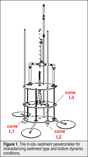 a
relatively short distance (1-3 cm) and can provide information on
surficial sediments. The heavier and narrower cones, L2 and L3,
penetrate further into the sediments and provide more useful information
on prevailing bottom conditions. Four zones that can be delineated
with penetrometer data are erosion, transport, probable accumulation,
and accumulation. Empirical relationships have been developed showing
that when values of L2 > 10 cm, then sediment accumulation predominates
and the sediments will be characterized by silts and clays with
relatively high moisture and organic contents and low bulk density.
Values of L2 < 3 cm indicate erosional bottoms dominated by sands
and gravel with high bulk density and low moisture and organic content.
Zones of sediment transport (areas intermittently accumulating sediments
that are later transported away) are indicated when 6 cm < L2
< 10 cm and the ratio of L3/L2 < 1.8.
a
relatively short distance (1-3 cm) and can provide information on
surficial sediments. The heavier and narrower cones, L2 and L3,
penetrate further into the sediments and provide more useful information
on prevailing bottom conditions. Four zones that can be delineated
with penetrometer data are erosion, transport, probable accumulation,
and accumulation. Empirical relationships have been developed showing
that when values of L2 > 10 cm, then sediment accumulation predominates
and the sediments will be characterized by silts and clays with
relatively high moisture and organic contents and low bulk density.
Values of L2 < 3 cm indicate erosional bottoms dominated by sands
and gravel with high bulk density and low moisture and organic content.
Zones of sediment transport (areas intermittently accumulating sediments
that are later transported away) are indicated when 6 cm < L2
< 10 cm and the ratio of L3/L2 < 1.8.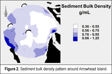 In
order for these penetrometer readings to be useful, the penetration
depths must be related to measurable sediment parameters. To develop
these relationships, the top ten centimeters of the sediment cores
were analyzed for sediment bulk density, moisture content, and organic
content. The results of a stepwise, multiple regression of the penetration
depths of the three cones and sediment bulk density indicates that
83% of the variance in bulk density can be explained by penetration
depths of rods L3 and L1. The inclusion of L2 into the regression
does not make a significant contribution to the explanation of the
bulk density variance. These results indicate that the penetrometer
can “capture” approximately 83% of the changes in sediment
bulk density across the sampled area. Sediment bulk density is closely
related to sediment moisture content. Most (99%) of the variance
in sediment moisture content can be explained by a second-order
function of bulk density. In a similar manner, 88% of the variance
in sediment organic content can be explained by the bulk density
of the sediments.
In
order for these penetrometer readings to be useful, the penetration
depths must be related to measurable sediment parameters. To develop
these relationships, the top ten centimeters of the sediment cores
were analyzed for sediment bulk density, moisture content, and organic
content. The results of a stepwise, multiple regression of the penetration
depths of the three cones and sediment bulk density indicates that
83% of the variance in bulk density can be explained by penetration
depths of rods L3 and L1. The inclusion of L2 into the regression
does not make a significant contribution to the explanation of the
bulk density variance. These results indicate that the penetrometer
can “capture” approximately 83% of the changes in sediment
bulk density across the sampled area. Sediment bulk density is closely
related to sediment moisture content. Most (99%) of the variance
in sediment moisture content can be explained by a second-order
function of bulk density. In a similar manner, 88% of the variance
in sediment organic content can be explained by the bulk density
of the sediments.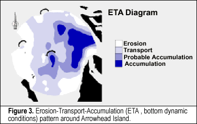 The
“hydraulic cushion” results from water building up around
the upstream face of the island and deflecting around the island.
This smaller area is also a relatively low energy zone where material
can settle out of suspension. While Figure 2 only illustrates the
pattern in sediment bulk density, the distribution of sediment moisture
and organic content is very similar. Using penetrometer readings
and sediment core data, a map of the bottom dynamic conditions,
or an ETA (Erosion-Transport- Accumulation) diagram, for the area
around Arrowhead Island was developed (Figure 3). The area behind
Arrowhead Island is clearly a zone of accumulation as previously
indicated by its low sediment bulk density, high moisture content,
and high organic content. Zones of erosion and transport predominate
in the area around Arrowhead Island.
The
“hydraulic cushion” results from water building up around
the upstream face of the island and deflecting around the island.
This smaller area is also a relatively low energy zone where material
can settle out of suspension. While Figure 2 only illustrates the
pattern in sediment bulk density, the distribution of sediment moisture
and organic content is very similar. Using penetrometer readings
and sediment core data, a map of the bottom dynamic conditions,
or an ETA (Erosion-Transport- Accumulation) diagram, for the area
around Arrowhead Island was developed (Figure 3). The area behind
Arrowhead Island is clearly a zone of accumulation as previously
indicated by its low sediment bulk density, high moisture content,
and high organic content. Zones of erosion and transport predominate
in the area around Arrowhead Island.Page Last Modified: April 17, 2018