|
Periodic land cover maps of the Upper Mississippi River System
(UMRS) floodplain are required by resource managers to understand
and monitor the system. Typically, land cover maps for the UMRS
are produced through interpretation of aerial photography and stored
as geographic information system ARC/INFO coverages. True-color
and color-infrared photos (scale = 1:15,000) of the entire UMRS
were collected in 1989 as part of the Long
Term Resource Monitoring Program (LTRMP). Nearly the entire
UMRS floodplain was interpreted from these photos. The exceptions
were Pools 1-3, most of the Open River (the UMRS from Lock &
Dam 26 located near Alton, Illinois downstream to its confluence
with the Ohio River near Cairo, Illinois), and about half of the
Illinois River.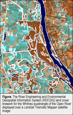 Sections of the UMRS have been rephotographed and interpreted in
subsequent years, but the same gaps in coverage remain. In an effort
to fill these gaps, land cover data for the Open River were acquired
by the U.S. Army Corps of Engineers (USACE) to incorporate into
their River Engineering and Environmental Geospatial Information
System (REEGIS, Figure). Recently, a conversion routine was developed
by Environmental Management Technical Center staff to translate
REEGIS data from Intergraph Design files to ARC/INFO coverages.
Sections of the UMRS have been rephotographed and interpreted in
subsequent years, but the same gaps in coverage remain. In an effort
to fill these gaps, land cover data for the Open River were acquired
by the U.S. Army Corps of Engineers (USACE) to incorporate into
their River Engineering and Environmental Geospatial Information
System (REEGIS, Figure). Recently, a conversion routine was developed
by Environmental Management Technical Center staff to translate
REEGIS data from Intergraph Design files to ARC/INFO coverages.
The Lower Mississippi Division of the USACE formed a River Database
Working Group in November of 1992, with the task of developing a
comprehensive geospatial database of the lower Mississippi and its
tributaries. The resulting REEGIS database brought together twenty-eight
existing thematic layers including flood control structures, geology,
hydrography and land cover.
The REEGIS land cover for the leveed floodplain of the Lower Mississippi
River exists as 50-meter resolution raster files for 1982 and 1992
and as a vector file for 1994. The 1994 layer was interpreted from
1:24,000 scale panchromatic aerial photographs, with a minimum mapping
unit (MMU) of 5 acres for wetlands and 20 acres for non-wetlands.
The primary software used in REEGIS is Intergraph’s Modular
GIS Environment (MGE). The MGE stores each data layer as a design
(*.dgn) file of graphic elements (e.g., polygons with labels at
their centroids) and an associated attribute table or tables within
a relational database. Each graphic feature in the design file is
linked to a specific record in the table(s). While Intergraph design
files may support up to 64 separate graphic levels, REEGIS is organized
so that only one theme is contained in each *.dgn file.
|
|
The 1994 land cover for the St. Louis District was acquired as
a single, seamless vector file (fwland94.dgn) and associated attribute
data file (fwland94.dmp). The following basic guidelines were used
to convert the 1994 land cover layer to an ARC/INFO coverage. These
steps may not be exactly the same for all REEGIS conversions. For
more information, consult the ARC/INFO on-line help for the commands
“IGDSINFO” and “IGDSARC,” as well as on-line
help under “Contents>Data Automation> Data Conversion>
Converting IGDS data.” The author will provide a more detailed
explanation of the conversion, including examples of command usage,
upon request.
Basic guidelines for file conversion:
- Determine the element Levels and Types in the IGDS file, using
IGDSINFO. Your data source should also be able to provide this
information. “Levels” correspond to graphic layers
in the IGDS file. “Types” refer to the kind of element
(e.g., cell, line, shape).
- Convert the levels of interest in the graphic file from design
format to an ARC/INFO coverage, using IGDSARC. Note that REEGIS
files should be identified as 3D, though (in this instance)
the z-value is set to zero. Wildcards (*) should be used in
the subcommands, so that IGDSARC can substitute appropriate
values from the design file. Only the layer name and layer number
need to be specified.
- Use the CLEAN command to build polygon topology and set the
“fuzzy tolerance.” The fuzzy tolerance determines
how vertices, or changes in directions along lines, are treated
in the conversion. It is important to set a low (e.g., “1”)
fuzzy tolerance because of the small MMU of these coverages.
If the fuzzy tolerance is not low enough, lines may shift and
centroids end up outside their polygons, resulting in label
errors. The REEGIS data should have correct line work, with
one label per polygon.
Linking Attributes:
- Convert the attribute file to an INFO file. The REEGIS provides
element attributes in a separate, data-dump (*.dmp) file. The
file consists of a header followed by the actual data records.
Bring the file into a word processor or text editor, delete
the header, and replace the spaces between fields with a single
comma, creating a comma-delimited ascii file.
- In ARC/INFO, define an INFO file (e.g., fwland94_3d.asc) corresponding
to the fields in the ascii file, then add the records from the
ascii file into the INFO file.
- Restore the links between graphic features and their attributes.
The command IGDSARC creates several INFO files, including a
file named *.dmrs. The *.dmrs file provides a bridge between
the basic polygon attribute table (*.pat) for the graphic features
and their extended attributes (in the *.asc file just created).
The item “[cover]-ID” in the *.dmrs file links backs
to the same item in *.pat, and another item (“OCCUR”)
in the *.dmrs links forward to the item “MSLINK” in
the file *.asc. The item “MSLINK” first must be added
to the *.dmrs file, and its value calculated from the item “OCCUR”.
Then the *.asc file can be joined to the *.dmrs, which in turn
is joined to the *.pat. The result is a fully-attributed ARC/INFO
coverage.
Additional work is required to fully integrate non-program data
such as REEGIS with the LTRMP database. Spatial and thematic accuracy
standards must be met. To the extent possible, the land cover schemes
must be “cross-walked” so that REEGIS categories can be
reclassed into their equivalent LTRMP categories. When this work
is completed, the 1994 REEGIS land cover data will be made available
to the LTRMP community. With some modification, this routine may
also be used to convert other themes within the REEGIS database
into a format compatible with LTRMP data.
|
|
This report is a product of the Long
Term Resource Monitoring Program for the Upper Mississippi River
System.
For further information, contact
Peter E. Joria
U.S. Geological Survey
Upper Midwest Environmental Sciences Center
575 Lester Avenue
Onalaska, Wisconsin 54650
Phone: 608/783-7550, ext. 703
E-mail:pete_joria@usgs.gov
Project Status Reports (PSRs) are preliminary documents whose purpose
is to provide information on scientific activities. Because PSRs
are only subject to internal peer review, they may not be cited.
Use of trade names does not imply U.S. Government endorsement of
commercial products.
All Project Status Reports are accessible through the Upper Midwest
Environmental Sciences Center’s website at http://umesc.usgs.gov/reports_publications/psrs/umesc_psr.html
|
