
|
PSR 97-11 October 1997 Evaluating Agricultural Nonpoint Loadings on Pool 13 from Maquoketa River Watershed, Iowaby Dr. Prasanna H. Gowda |
|
Floodplains of the Upper Mississippi River System (UMRS) are continuously receiving high sediment and nutrient (nitrate-N, phosphorus, pesticides) discharges from their tributary watersheds, primarily as a result of nonpoint agricultural runoff, that are affecting the quality of backwaters and contributing to eutrophication. Continued degradation of backwaters by sedimentation and nutrient enrichment are expected to adversely influence aquatic habitat by reducing its extent and diversity within the next 50 to 100 years. Thus, a scientific inquiry is needed to (1) understand the magnitude and spatial patterns of sediment and nutrient loadings and (2) quantify the benefits of alternative potential management strategies for agricultural areas in the Upper Mississippi River Basin. Results would provide a framework for planning and help watershed managers and policy makers develop effective management policies. The objectives of this research are to (1) predict agricultural nonpoint source loadings of sediment, nitrate- N, phosphorus and pesticides from the Maquoketa River watershed by using an integrated spatial-process model; (2) use observed and predicted runoff, sediment, and agrichemical loadings for model evaluation; and (3) use the model to evaluate potential water quality benefits associated with the adoption of alternative watershed management strategies. This information will assist both the U.S. Department of Agriculture and the U.S. Environmental Protection Agency as well as Pool 13's natural resource managers. |
|
The Maquoketa River watershed (1694 mi 2 ), located in northeastern
Iowa, is an agriculturally predominated watershed of the Upper Mississippi
River Basin. |
|
A land cover/land use layer for the watershed was derived from
the satellite (Landsat Thematic Mapper) data, acquired on September
1, 1995, using a hybrid classification technique. Figure 2 Study findings and developmental efforts will be disseminated through the publication of two research papers in referred journals. The developed GIS database will be used by staff at the Environmental Management Technical Center and University of Wisconsin-La Crosse to integrate the physical, biological, and socioeconomic components of the watershed in order to develop alternative best management practices. The GIS database will also be made available to the public through the internet. |
|
This report is a product of the Long Term Resource Monitoring Program for the Upper Mississippi River System. For further information, contact Dr. Prasanna H. Gowda U.S. Geological Survey Project Status Reports (PSRs) are preliminary documents whose purpose is to provide information on scientific activities. Because PSRs are only subject to internal peer review, they may not be cited. Use of trade names does not imply U.S. Government endorsement of commercial products. All Project Status Reports are accessible through the Upper Midwest Environmental Sciences Center’s website at http://umesc.usgs.gov/reports_publications/psrs/umesc_psr.html |
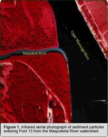 Sediment
loadings from this watershed drain directly into
Sediment
loadings from this watershed drain directly into 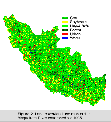 illustrates
the land cover/land use map of the Maquoketa River watershed for
1995. Ground truth data collected from the Farm Service Agency were
used for identifying agricultural crops. A TM-based logistic regression
model was used to identify tillage management practices (till and
no-till) in the watershed using Landsat TM data aquired on March
27, 1996. To avoid non-agricultural areas being classified as till
or no-till areas, they were masked out using the land cover/land
use map of the watershed. A digital soil layer, showing the soil
map units in the watershed, was extracted from the State Soil Geographic
(STATSGO) soil database for Iowa and the soil characteristics associated
with the soil map units are being derived from the Map Unit Use
File (MUUF), a PC-based Natural Resource Conservation Service (NRCS)
soil database. A slope map was derived from a 1:250,000 scale USGS
digital elevation model. A GIS interface to derive transformed hydrological
response units and display hydrographs and associated quality graphs
for the watershed has been developed. Currently, the interface is
being tested with the GIS database developed for the Maquoketa River
watershed. Model input such as planting dates, chemical application
rates and climatic data are being collected from a variety of sources,
including published reports and surveys.
illustrates
the land cover/land use map of the Maquoketa River watershed for
1995. Ground truth data collected from the Farm Service Agency were
used for identifying agricultural crops. A TM-based logistic regression
model was used to identify tillage management practices (till and
no-till) in the watershed using Landsat TM data aquired on March
27, 1996. To avoid non-agricultural areas being classified as till
or no-till areas, they were masked out using the land cover/land
use map of the watershed. A digital soil layer, showing the soil
map units in the watershed, was extracted from the State Soil Geographic
(STATSGO) soil database for Iowa and the soil characteristics associated
with the soil map units are being derived from the Map Unit Use
File (MUUF), a PC-based Natural Resource Conservation Service (NRCS)
soil database. A slope map was derived from a 1:250,000 scale USGS
digital elevation model. A GIS interface to derive transformed hydrological
response units and display hydrographs and associated quality graphs
for the watershed has been developed. Currently, the interface is
being tested with the GIS database developed for the Maquoketa River
watershed. Model input such as planting dates, chemical application
rates and climatic data are being collected from a variety of sources,
including published reports and surveys.Page Last Modified: April 17, 2018