
|
PSR 97-02 April 1997 Longitudinal Changes in Mississippi River Floodplain Structureby Robert L. Delaney1 and Mary R. Craig2 |
|
The Mississippi River is by far the largest riverine ecosystem in North America and the third largest in the world; the River’s floodplain and deltaic plain encompass nearly 30 million acres. Draining 41% of the contiguous United States, the River is one of the most significant environmental factors affecting the Gulf of Mexico. Valued as a natural, historical, cultural, commercial, recreational, and transportation resource, the Mississippi River has had a major influence on the settlement and development of the United States. The River’s 1,250,000-square-mile drainage basin is dominated by agricultural activities and the associated millions of pounds of herbicides, insecticides, and nitrogen based fertilizers that are applied annually for purposes of increasing crop yields. Many of these chemical compounds are transported into the Mississippi River and subsequently discharged into the Gulf of Mexico, where they may be contributing to a growing 7,000-square-mile hypoxic zone within the Gulf. This main inland transportation artery moves nearly 500 million tons of goods yearly, including nearly 42% of the grain exported from the United States. Roughly 12 million people live along the mainstem of the River and annually generate about $7.1 billion in agricultural and forest products and $429 billion in manufactured goods. Recreational use and tourism along the River account for more than $10 billion in annual revenues. The River and its tributaries still support a broad array of fish and wildlife, including 241 fish species, approximately 50 species of mammals, 45 species of reptiles and amphibians, and 37 species of mussels. The river corridor functions as a migratory flyway for up to 40% of all North American waterfowl and 60% of all U.S. bird species. During the past 200 years, the Mississippi River and its floodplain have been-and continue to be- seriously degraded by extensive water pollution, wetland drainage, deforestation, habitat fragmentation, water-flow modification, and floodplain development. Two of the most deleterious river modifications have been (1) levee construction, resulting in a 90% reduction in the amount of seasonally inundated floodplain and (2) alignment and maintenance of the navigation channel traversing 85% of the River’s length. Altered hydrology and sedimentation patterns have progressed to the point that geomorphic processes have been severely disrupted. A growing body of evidence indicates that physical (geomorphic) processes and features control the biological structure and diversity of large floodplain rivers, particularly at large spatial scales. Scientists generally agree that the ecological diversity and integrity of large floodplain rivers are maintained by fluvial dynamics (annual flood pulses and channel-forming floods) and river-floodplain connectivity. Anything that tends to suppress the natural flood regime or constrain channel migration will disrupt these interactive pathways and lead to reduced ecological diversity and integrity. |
 |
|
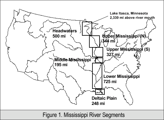
This investigation applies the above assumptions about large floodplain
rivers to the mainstem floodplain of the 2,339-mile Mississippi
River. Figure 1 divides and names segments along the Mississippi
River on the general basis of common geomorphic structure. Along
roughly 80% of the River’s length, including the upper, middle,
lower, and deltaic plain segments, the channel is fixed in place
as a commercial navigation channel by a variety of channel training
structures (wing dams, dikes, and revetments). |
|
1Director |
|
|
|
This report is a product of the Long Term Resource Monitoring Program for the Upper Mississippi River System. For further information, contact U.S. Geological Survey
Project Status Reports (PSRs) are preliminary documents whose purpose is to provide information on scientific activities. Because PSRs are only subject to internal peer review, they may not be cited. Use of trade names does not imply U.S. Government endorsement of commercial products. All Project Status Reports are accessible through the Upper Midwest Environmental Sciences Center’s website at http://umesc.usgs.gov/reports_publications/psrs/umesc_psr.html |
 The
fluvial dynamics once responsible for channel migration across the
floodplain, for alternating terrestrial and aquatic phases on the
floodplain surface, and for sustaining a diverse array of aquatic
habitat types and alluvial forest successional stages have largely
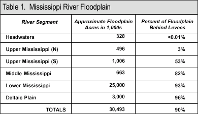
been arrested along 80% of the River’s length. Table 1 compares
each river segment’s total floodplain acreage with the percentage
of floodplain that has been isolated from the main river channel.
Note that there is a progressive downstream isolation of the floodplain,
with 90% of the total Mississippi River floodplain largely isolated
from the main channel by levees. If the applied assumptions are
correct-that geomorphic structure, fluvial dynamics, and river-floodplain
connectivity largely control ecological diversity and integrity
of large floodplain rivers-then, given the current influences along
the mainstem floodplain of the Mississippi River, future ecological
conditions can be expected to deteriorate progressively downstream.
To arrest deteriorating ecological conditions, some level of physical
remedial action, including habitat rehabilitation and enhancement,
will be necessary and will likely require sustained efforts.
The
fluvial dynamics once responsible for channel migration across the
floodplain, for alternating terrestrial and aquatic phases on the
floodplain surface, and for sustaining a diverse array of aquatic
habitat types and alluvial forest successional stages have largely
been arrested along 80% of the River’s length. Table 1 compares
each river segment’s total floodplain acreage with the percentage
of floodplain that has been isolated from the main river channel.
Note that there is a progressive downstream isolation of the floodplain,
with 90% of the total Mississippi River floodplain largely isolated
from the main channel by levees. If the applied assumptions are
correct-that geomorphic structure, fluvial dynamics, and river-floodplain
connectivity largely control ecological diversity and integrity
of large floodplain rivers-then, given the current influences along
the mainstem floodplain of the Mississippi River, future ecological
conditions can be expected to deteriorate progressively downstream.
To arrest deteriorating ecological conditions, some level of physical
remedial action, including habitat rehabilitation and enhancement,
will be necessary and will likely require sustained efforts.Page Last Modified: April 17, 2018