
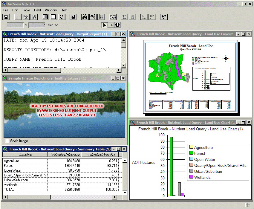
Acadia National Park Nutrient Load and Estuarine Response Decision Support SystemThe Resource Management Plan for Acadia National Park identifies nutrient loading of aquatic systems as one of the park's most significant resource management challenges. Excessive nutrient enrichment of estuaries can lead to eutrophication and concomitant losses of biological diversity and habitat value. Baseline investigations have highlighted the susceptibility of Acadia's estuaries to nutrient inputs and the threats posed by changes in land use outside the Park's boundaries. A Decision Support System was constructed using Environmental Systems Research Institute, Inc (ESRI), ArcView 3.x technology to quantify the effects of land use change within the watershed with respect to nutrient loading to the estuary. The Acadia National Park Nutrient Load and Estuarine Response Decision Support System (NLERDSS) consists of two tools: The first tool is the Nutrient Load and Estuarine Response Tool (NLERT). The purpose of the NLERT is to calculate nutrient loading to the Northeast Creek estuary based solely upon land use composition within the Northeast Creek watershed. For the NLERT, total nutrient load is calculated by multiplying the area of each land use type within the watershed by the nutrient export coefficient of each land use type, and then summing these values. The NLERT compares the nutrient loading statistics of a selected area of interest (AOI) to the watershed as a whole and also predicts long-term ecosystem (estuarine) responses to the level of nutrient loading based on numerical thresholds calculated in situ. The user also has the ability to make hypothetical area changes and nutrient coefficient value changes to the AOI to quantify these changes (Figure 1).
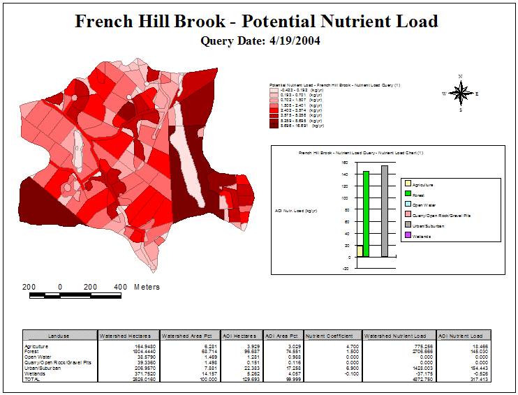
Outputs from this tool include GIS themes, tables, charts, maps and textual reports (Figure 2 and Figure 3).
The second tool is the Land Use Polygon Edit Tool (LUPET). With LUPET, the user is given the ability to alter the land use composition within the watershed by making spatially-explicit changes to the theme. This gives the user the ability to quantify the effects of land use change (e.g., increased urbanization) within the watershed on the level of nutrient loading to the estuary. The outputs from this tool include an updated land use theme and an updated metadata file for this theme. Jason J. Rohweder1, Timothy J. Fox1, Glenn R. Guntenspergen2, Martha G. Nielsen3, and Hilary A. Neckles2 1U.S. Geological Survey 2U.S. Geological Survey 3U.S. Geological Survey Principal Investigator: Jason Rohweder |
||||

Page Last Modified: April 17, 2018