|
Upper Mississippi River Restoration ProgramLong Term Resource Monitoring |
|
| |
||
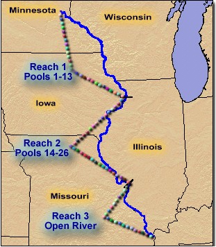
The reach and pool pages are used to access Web pages that contain links to aerial photographs, GIS data, and project information. The reaches themselves are used to describe areas of similar geomorphology, vegetation cover, and land use practices.
| Reach 1 - Navigation Pools 1 through 13 |
|
|
Reach 1 extends from Minneapolis, Minnesota to Lock and Dam 13 located near Clinton, Iowa. This reach contains large areas of off-channel water and large acreages of aquatic vegetation. Only 3% of the relatively narrow floodplain is located behind agricultural levees. |
|
| Reach 2 - Navigation Pools 14 through 26 | |
|
Reach 2 extends from Lock and Dam 13 to Lock and Dam 26. The floodplain in this reach contains limited aquatic vegetation, a higher proportion of water in channels, and 53% of the floodplain is located behind agricultural levees. |
|
| Reach 3 - Lock and Dam 26 to the confluence with the Ohio River | |
|
Reach 3 extends from Lock and Dam 26 to the river's confluence with the Ohio River. This reach contains almost no aquatic vegetation, a high proportion of the water in channel habitats, and 82% of the floodplain is located behind agricultural levees. |
|
| About the Upper Mississippi River System |