Upper Mississippi River Restoration Program

Upper Mississippi River Restoration Program

Long Term Resource Monitoring


Aquatic Vegetation


Standardized Monitoring
Background
 Methods
      Stratified Random
      Transect
Sampling History
Graphical Browser
Annual Update
Data Downloads
      Stratified Random
      Transect
      Informal Surveys
Stratified Random Sampling 2024 sites
      (LTRM Field Station Use Only)
Focused Research
Predictive Models
USGS Scientists 
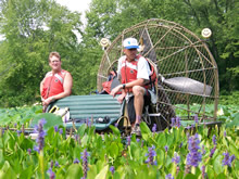
Aquatic vegetation in the Upper Mississippi River System (UMRS) provides food, spawning areas, and shelter to fish, wildlife, and invertebrates.

The objective of the LTRM element standardized monitoring is to accumulate data on the distribution, frequency of occurrence, and relative abundance of aquatic vegetation over a long period of time. The LTRM currently uses a stratified random sampling design in Pools 4, 8, and 13. In the past, other pools were sampled and other designs (e.g., transects and informal surveys) were used.


Component lead: Danelle Larson

Quick links
LTRM Reports and Publications
Sampling Design and Statistics
Aquatic Vegetation Procedures Manual
Upper Mississippi River Landcover Viewer
Land Cover/Use Data
 
Strategic Plan 2010-2014
Status and Trends Report 2008


Accessibility FOIA Privacy Policies and Notices

Take Pride in America logo USA.gov logo U.S. Department of the Interior | U.S. Geological Survey


Page Last Modified: February 22, 2022 US Army Corps of Engineers USGS Upper Midwest Environmental Sciences Center US Fish and Wildlife Service U.S. Environmental Protection Agency U.S. Department of Agriculture Natural Resources Conservation Service Minnesota DNR Wisconsin DNR Iowa DNR Illinois Natural History Survey Missouri DC