Upper Midwest Environmental Sciences Center
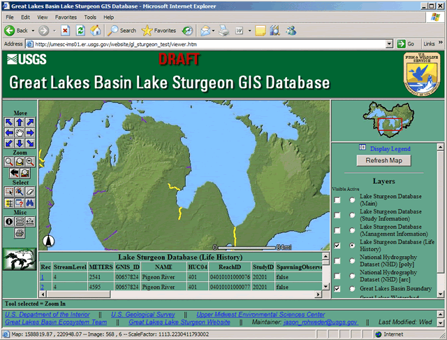
Great Lakes Basin Lake Sturgeon GIS DatabaseThe Great Lakes Basin Ecosystem Team (GLBET) Lake Sturgeon Committee collaborated with the U.S. Geological Survey Upper Midwest Environmental Sciences Center (UMESC) to create a prototype webpage to graphically display Lake Sturgeon sampling information collected within the Great Lakes Basin. Staff members from UMESC participated in several meetings and workshops with GLBET Lake Sturgeon committee members. The UMESC then created a prototype web-based Environemental System Research Institute's (ESRI) ArcIMS (Internet Map Server) Decision Support System (DSS) to display this information (Figure 1).
Field staff within the Great Lakes Basin have been entering Lake Sturgeon sampling information into a database structure that will link to the National Hydrographic Dataset (streams) for display in an interactive web-based application. This project will significantly enhance a unified, interactive web-based GIS application and meta-database of Great Lakes lake sturgeon information important to researchers and managers. The database will improve upon the existing maps and database developed for the 2000 and 2002 Great Lakes Fishery Trust (GLFT) Lake Sturgeon Workshops. The GLFT Workshop base maps and database identifies and categorizes all known lake sturgeon waters within the Great Lakes Basin into extirpated, historic, reintroduced, and/or current lake sturgeon populations. This project has created a metadata structure that broadens the information that can be stored and made available to researchers. Greater resolution of the degree of use or presence in a river system has been added for all populations. Where available, information is referenced for presence of adults, juveniles, and subadults, and whether spawning has been observed, egg deposition documented, and larvae captured. Data fields reporting sampling methods used, whether contaminant, genetic, or aging samples were collected, date(s) or year(s) for which the information was collected, investigator(s) involved, citations for available Products and Publications, and point of contact for additional information are included. The long-term objective is to compile the available lake sturgeon data sources to help focus restoration and research activities on priority lake sturgeon waters. The prototype website was created for the GLBET Lake Sturgeon Committee and will be built upon by the GIS working group of that committee. Principal Investigators: Jason Rohweder |
Page Last Modified: April 3, 2018