
Upper Midwest Environmental Sciences Center
| Field Station | River | River Pool | Start Year - End Year |
|---|---|---|---|
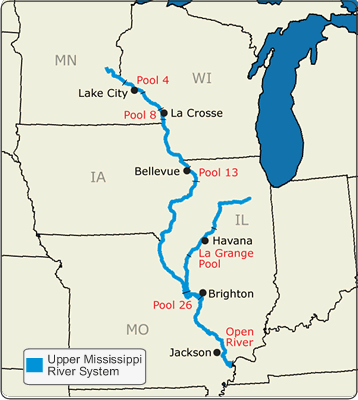
| 1 (Lake City, Minnesota) | Mississippi | Pool 4 | 1998 - Present |
| 1 (Lake City, Minnesota) | Mississippi | Pool 5 | 2002 - 2002 |
| 2 (La Crosse, Wisconsin) | Mississippi | Pool 7 | 2002 - 2002 |
| 2 (La Crosse, Wisconsin) | Mississippi | Pool 8 | 1998 - Present |
| 3 (Bellevue, Iowa) | Mississippi | Pool 12 | 2002 - 2002 |
| 3 (Bellevue, Iowa) | Mississippi | Pool 13 | 1998 - Present |
| 4 (Alton, Illinois) | Mississippi | Pool 26 | 1998 - 2004 |
| 4 (Alton, Illinois) | Illinois | Lower Alton | 2002 - 2002 |
| 6 (Havana, Illinois) | Illinois | La Grange | 1998 - 2004 |
| 6 (Havana, Illinois) | Illinois | Upper Alton | 2002 - 2002 |
| Life Form Codes | Life Form |
|---|---|
| S | Submergent Species |
| F | Rooted Floating-leaf Species |
| E | Emergent Species |
| A | Filamentous Algae |
| N | Non Rooted Floating-leaf Species |
|
The shapefile download option creates a file that contains vector graphics that represent georeferenced points of the data. The shapefile comes with a dbf file for storing the data, a projection file to describe how the points are georeferenced and an index file for accessing records in the shape file. Shapefiles can be easily added to ESRI's ArcMAP software and other mapping applications. |
|
The DBF download option creates a binary file that contains the records of the data in a format that specifies the columns and the datatypes of the columns. The dbf file format can be easily imported into applications like Microsoft Access and ESRI ArcMAP. |
|
The Extensible Markup Language(XML) download option creates a text file that contains the records of the data in a tagged format that adheres to XML 1.0 specification. The XML file is a text file where each row is contained in a tag and the fields are contained in sub tags. This format is easily shared amongst various programs and applications accross various operating system platforms. |
|
The Comma Separated Values(CSV) download option creates a text file that contains the records of the data one record per row with column fields being separted by a comma. The first line of the file contains the column names separated by a comma. The CSV format is easily imported in various Microsoft Office applications and most programs that allow importing of data. |
| Browser Field Name | Browser Field Name Abbreviations |
|---|---|
| BARCODE | BARCODE |
| PAGE NUMBER | PAGENUM |
| ROW NUMBER | ROWNUM |
| FIELD STATION NUMBER | FLDNUM |
| PROJECT CODE | PROJCD |
| POOL/REACH | POOL |
| DATE | DATE |
| CREW LEADER CODE | LDRCODE |
| RECORDER CODE | RCRDCODE |
| DETRITUS | DETRITUS |
| PREDOMINANT SUBSTRATE | SBSTRATE |
| SITE CODE | SITECD |
| MAP STRATUM | MSTRATUM |
| ACTUAL STRATUM | ASTRATUM |
| RIVER MILE | RIVMILE |
| SUBMERSED VEGETATION | VEG_S |
| ROOTED FLOATING LEAF VEGETATION | VEG_RF |
| EMERGENT VEGETATION | VEG_E |
| ALGAE | VEG_A |
| NONROOTED FLOATING LEAF VEG. | VEG_NRF |
| UNVEGETATED | VEG_U |
| NONROOTED FLOATING COVER | COV_NRF |
| ROOTED FLOATING COVER | COV_RF |
| EMERGENT COVER | COV_E |
| 1ST UTM EASTING | EAST1 |
| 1st UTM NORTHING | NORTH1 |
| UTM ZONE | ZONE |
| 1ST ACCURACY | ACCUR1 |
| UTM METHOD | METHOD |
| 2ND UTM EASTING | EAST2 |
| 2ND UTM NORTHING | NORTH2 |
| 2ND UTM ACCURACY | ACCUR2 |
| UMESC UTM ZONE | ZONE_U |
| UMESC UTM EASTING | EAST_U |
| UMESC UTM NORTHING | NORTH_U |
| GIS GRID CODE | GRIDCODE |
| ZONE15 EAST/WEST | EAST_15 |
| ZONE15 NORTH/SOUTH | NORTH_15 |
| HABITAT SUBSAMPLES 1 | HABITAT1 |
| HABITAT SUBSAMPLES 2 | HABITAT2 |
| HABITAT SUBSAMPLES 3 | HABITAT3 |
| HABITAT SUBSAMPLES 4 | HABITAT4 |
| HABITAT SUBSAMPLES 5 | HABITAT5 |
| HABITAT SUBSAMPLES 6 | HABITAT6 |
| WATER DEPTH SUBSAMPLES 1 | DEPTH1 |
| WATER DEPTH SUBSAMPLES 2 | DEPTH2 |
| WATER DEPTH SUBSAMPLES 3 | DEPTH3 |
| WATER DEPTH SUBSAMPLES 4 | DEPTH4 |
| WATER DEPTH SUBSAMPLES 5 | DEPTH5 |
| WATER DEPTH SUBSAMPLES 6 | DEPTH6 |
| PLANT DENSITY SUBSAMPLES 1 | DENSITY1 |
| PLANT DENSITY SUBSAMPLES 2 | DENSITY2 |
| PLANT DENSITY SUBSAMPLES 3 | DENSITY3 |
| PLANT DENSITY SUBSAMPLES 4 | DENSITY4 |
| PLANT DENSITY SUBSAMPLES 5 | DENSITY5 |
| PLANT DENSITY SUBSAMPLES 6 | DENSITY6 |
| SITE BATCH NUMBER | BATCHNUM |
| SPECIES CODE | SPPCD |
| VISUAL SUBSAMPLES 1 | VISUAL1 |
| VISUAL SUBSAMPLES 2 | VISUAL2 |
| VISUAL SUBSAMPLES 3 | VISUAL3 |
| VISUAL SUBSAMPLES 4 | VISUAL4 |
| VISUAL SUBSAMPLES 5 | VISUAL5 |
| VISUAL SUBSAMPLES 6 | VISUAL6 |
| RAKE SUBSAMPLES 1 | RAKE1 |
| RAKE SUBSAMPLES 2 | RAKE2 |
| RAKE SUBSAMPLES 3 | RAKE3 |
| RAKE SUBSAMPLES 4 | RAKE4 |
| RAKE SUBSAMPLES 5 | RAKE5 |
| RAKE SUBSAMPLES 6 | RAKE6 |
| ADDITIONAL SPECIES | ADDSPP |
| SPECIES COVER | COVSPP |
| QE CODE | QECODE |
| VOUCHER | VOUCHER |
| COMMENT | COMMENT |
Vegetation Stratified Random Sampling (SRS) Database Browser
This Vegetation SRS Database Browser provides the most complete access to raw data using the widest variety of query parameters.
Please read the UMESC LTRMP Database Browser Notes before using this browser.
For Vegetation metadata read the FGDC NBII, Vegetation SRS Metadata page.
For Vegetation SRS component information read the Component Information Page which contains a description, history and value ranges of the data.
Queries made using the Vegetation SRS Database Browser are real time, it may take a few minutes to retrieve your results.
Note: Coordinates are now served in North American Datum 1983
